|
Shifty Nipples posted:Found a plane flying over the Columbia River. Wow, the lack of perspective makes it look like it's just above the ground. (It's totally not, judging by the lack of a shadow.)
|
 #
?
May 24, 2014 03:44
#
?
May 24, 2014 03:44
|
|


|

|
| # ? Apr 20, 2024 15:14 |
|
|
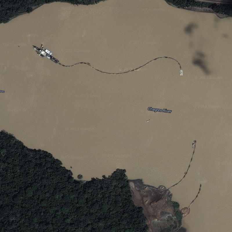 http://goo.gl/maps/AHTjL Dredge in the Panama canal. The soil and rock is being piped to the river edge.
|
|
#
?
May 29, 2014 01:22
|
|

|
Speaking of the Canal, if you were looking around, did you notice the random cuts of clear ground along the sides of the canal, like this? Curious what they are? Zoom out and follow them into the water, notice how they line up with the main channel (they line up exactly, in fact). They're Ranges which are two fixed boards that, when lined up one atop the other, tell a ship they're where they are supposed to be. Click here for the Maps link.
|
|
#
?
May 29, 2014 01:35
|
|


|
America has a new largest* park. Its name is Schenley Park, and it starts near Pittsburgh.  It leaves the city and crosses I‒79  Leaves the state and enters West Virginia  Passes through Ohio  Kentucky  Tennessee  Mississippi  Arkansas  Louisiana  It crosses into Texas at the Toldedo Bend reservoir.  As it progresses into Texas it becomes smaller and smaller  Till it vanishes entirely in West Livingston, TX. * Its area is actually only about 87 km2. Platystemon fucked around with this message at 04:06 on Jul 4, 2014 |
|
#
?
Jul 4, 2014 03:38
|
|

|
That is a huge pain in the rear end to fix on mapmaker too.
|
|
#
?
Jul 4, 2014 03:59
|
|
|
Schenley Park was the main place to go do drugs when I was in college, particularly at "the ledge". I approve of this expansion.
|
|
#
?
Jul 4, 2014 04:34
|
|

|
^^^Hey pittsburgher! Yeah that goes right by my house and I have not a clue about any park. The bike trails are workin out ok though.
|
|
|
#
?
Jul 4, 2014 04:53
|
|

|
The Feldman Felcher posted:^^^Hey pittsburgher! Yeah that goes right by my house and I have not a clue about any park. The bike trails are workin out ok though. I'm actually an ex-Californian and now live in Brooklyn, but I did my undergrad at CMU. I haven't been back to Pittsburgh in 12 years. I hear it's changed a lot since then (and not just because of the magic 2500 mile park expansion)
|
|
#
?
Jul 4, 2014 14:05
|
|
|
Platystemon posted:America has a new largest* park. holy loving poo poo I love this thread.
|
|
#
?
Jul 4, 2014 22:56
|
|

|
Platystemon posted:America has a new largest* park. That's got to be a mapping error right? it looks like someone accidentally dragged a node from the edge of that park down to Texas since it's straight and it narrows all the way down there too.
|
|
#
?
Jul 5, 2014 01:10
|
|


|
GutBomb posted:That's got to be a mapping error right? it looks like someone accidentally dragged a node from the edge of that park down to Texas since it's straight and it narrows all the way down there too. Yeah, it�s just a single misplaced vertex. The surprising thing is that there was no sanity check. I have been told that it�s been like that for more than a month.
|
|
#
?
Jul 5, 2014 01:40
|
|
|
Why is it so hard to fix? Couldn't someone just delete that point in Texas? Or do they have to literally erase the whole thing manually?
|
|
#
?
Jul 5, 2014 01:49
|
|
|
GutBomb posted:That's got to be a mapping error right?
|
|
#
?
Jul 5, 2014 15:50
|
|


|
Palpek posted:Nah, I think it's a real park. Well I wasn't thinking actual park, but when I was a teenager I worked as a data entry clerk for a phone company in Colorado digitizing old paper right-of-way permits from the 40s and there were a lot of maps with tiny strips of land like that where the phone lines were. They were marked so the technicians knew where they could go to work on phone lines that go across private property so they know when they are trespassing or not. I was pretty sure it was just a mistake but thought there might be a tiny chance that some sort of data for something like that (like a pipeline or something) made it's way into the google maps data. I remember posted earlier in the thread there was a satellite photo with a weird straight line that went across part of a city starting in a grocery store parking lot or something like that and it was over-ground points marking where a pipeline was underground.
|
|
#
?
Jul 5, 2014 22:19
|
|
|
Yeah it's a pipeline right-of-way that crosses the park.
|
|
#
?
Jul 6, 2014 03:58
|
|


|
withak posted:Yeah it's a pipeline right-of-way that crosses the park. No, it's quite clearly a vertex error. Aside from the fact that there's no pipeline there, pipelines do not run perfectly straight for thousands of miles over populated terrain, getting narrower as they go along.
|
|
#
?
Jul 6, 2014 13:05
|
|


|
Some pipelines do.
|
|
#
?
Jul 6, 2014 15:37
|
|
|
Earwicker posted:Why is it so hard to fix? Couldn't someone just delete that point in Texas? Or do they have to literally erase the whole thing manually? It's hard to fix because 99% of edits to google maps are done via google mapmaker, and done without a human interacting. It's easy to tell maps that the park's boundaries are wrong, but they're not:  What's wrong is the overlay(underlay?) and that's not something that I think you can change in mapmaker. So someone has to wade into the support forums and find a live person on the maps team and show them.
|
|
#
?
Jul 6, 2014 15:45
|
|
|
Misplaced vertexes are fair game now? Here's one showing a brand new runway that cuts across the entire downtown area of Singapore. It's the giant grey triangle: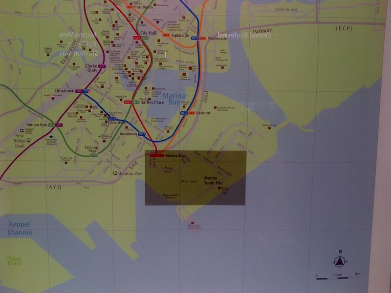
|
|
#
?
Jul 11, 2014 16:30
|
|
|
What UI for Google Maps is that?
|
|
#
?
Jul 11, 2014 17:48
|
|
|
kimihia posted:Misplaced vertexes are fair game now? Here's one showing a brand new runway that cuts across the entire downtown area of Singapore. It's the giant grey triangle: is that a printed map? How does that get past the proofreading stage?
|
|
#
?
Jul 11, 2014 17:58
|
|
|
Trap
|
|
#
?
Jul 11, 2014 23:12
|
|

|
Funny looking triangle.
|
|
#
?
Jul 11, 2014 23:32
|
|


|

|
|
#
?
Jul 16, 2014 19:11
|
|
|
Weird trench-looking thing in a local man-made lake by my house e: 
TheWordOfTheDayIs fucked around with this message at 21:43 on Jul 18, 2014 |
|
#
?
Jul 18, 2014 21:37
|
|

|
TheWordOfTheDayIs posted:Weird trench-looking thing in a local man-made lake by my house It's the original stream channel from before they built that dam, visible either through the water or because there is an IR component included in the image and the deeper water is colder.
|
|
#
?
Jul 18, 2014 21:40
|
|
|
I was wondering what these things in Manhattan's East River are: http://www.google.com/maps/@40.7548163,-73.9618046,172m/data=!3m1!1e3 Barge platforms? Atlantean skyscrapers? But if you zoom in on those blue/purple containers, you can make out the name "Phoenix Marine." Which turns out to be "the premiere marine construction company in the New York City Harbor area." So I guess they're floating construction platforms. Should I be worried that they appear to be sinking? 
|
|
#
?
Jul 24, 2014 00:40
|
|

|
Two Twitter feeds that this thread should find interesting: @BPEarth posts a random land image from Google Earth. @random_places posts a random Street View image. They post every 90 minutes, about 15 minutes apart. All the images are geotagged and it's just a cool thing.
|
|
#
?
Jul 24, 2014 02:38
|
|

|
I wonder how BPEarth weeds out ocean shots.
|
|
#
?
Jul 24, 2014 14:19
|
|
|
Cichlid the Loach posted:Should I be worried that they appear to be sinking? No the East River is already full of all kinds of crap like that, a little more won't hurt.
|
|
#
?
Jul 24, 2014 14:56
|
|
|
Maultaschen posted:Two Twitter feeds that this thread should find interesting: These are great! Thanks! Any feeds like them that post interesting stuff from Maps like in this thread?
|
|
#
?
Jul 26, 2014 22:07
|
|

|
Cichlid the Loach posted:Should I be worried that they appear to be sinking? They aren't sinking, it's just an artifact of how Google Maps fades one image into another. In this case, one image has the barge in it, but in the other the barge was moved somewhere else, so it just fades out weirdly in the composite of the two images.
|
|
#
?
Jul 26, 2014 22:41
|
|


|
Elendil004 posted:I wonder how BPEarth weeds out ocean shots. I'd imagine they have access to vector data and simply don't pick anything inside a water poly.
|
|
#
?
Jul 28, 2014 14:24
|
|
|
Not so much "identify" but last night I watched a show on Netflix called Forgotten Planet. The first episode was on Pripyat and Picher, Oklahoma. I've never heard of Picher and the story was terrible: former lead and zinc mining town that got poisoned from big piles of "chat" - the waste from mining lead and zinc. They showed huge piles of gravel that the residents said they used to play on, the playgrounds were made from chat, etc. The town eventually became the first superfund site and the gov't realized the damage was too much to repair so they bought everyone out. So this morning I went and looked at it: https://www.google.com/maps/@36.981113,-94.834973,14z Click on the satellite view to see all of the chat piles. loving sad and scary.
|
|
#
?
Aug 12, 2014 15:25
|
|


|
Rich Radbards posted:Click on the satellite view to see all of the chat piles. loving sad and scary. Streetview is even creepier, especially since there are still *some* people living there.
|
|
#
?
Aug 12, 2014 15:35
|
|
|
SybilVimes posted:Streetview is even creepier, especially since there are still *some* people living there. Yeah. One website says 6 people still live there, the show said no one. I noticed they didn't go down all the streets. The show also said that some of the miners reported seeing tree roots at the top of the mine, that they had dug too close to the surface. That whole town is going to disappear into a big sinkhole one of these days.
|
|
#
?
Aug 12, 2014 15:47
|
|
|
Rich Radbards posted:https://www.google.com/maps/@36.981113,-94.834973,14z Looks like a cancer from the air. Wikipedia says that a tornado in 2008 destroyed 150 houses and killed 8 people. Clearly this a place where the earth does not want people to be any more.
|
|
#
?
Aug 12, 2014 15:55
|
|
|
withak posted:Looks like a cancer from the air. Wikipedia says that a tornado in 2008 destroyed 150 houses and killed 8 people. Clearly this a place where the earth does not want people to be any more. That was also mentioned in the show. It's available to stream and I recommend watching it. The piece on Pripyat was interesting too.
|
|
#
?
Aug 12, 2014 15:58
|
|
|
If we dig precious things from the land we will invite disaster
|
|
#
?
Aug 12, 2014 16:11
|
|
|

|
| # ? Apr 20, 2024 15:14 |
|
|
Earwicker posted:If we dig precious things from the land we will invite disaster (Ten-minute slow motion shot of failed Atlas launch)
|
|
#
?
Aug 13, 2014 01:01
|
|