


|
I have a question. Why do traffic engineers decide that it's best to re-route traffic to newly built retail stores like WalMart and such through RESIDENTIAL AREAS!!!! What's an extra 10k cars a day through a street that barely got any traffic before. Is it your goal to make home owners extremely irate with you? Maybe that's not your call but perhaps you can shed some light on the subject.
|
 #
?
Oct 1, 2009 22:02
#
?
Oct 1, 2009 22:02
|
|

|

|
| # ? Apr 28, 2024 07:13 |
|
|
be Creative posted:I'm not sure if this has been answered because im lazy, but if that is the exit in New Canaan near the Stamford line it was a car accident. Actually my fathers friend died. I forget the whole backstory but he went off the road hit the sign and crashed into a tree. I'm sorry to hear that. It might be a good time to bring up NCHRP Report 350, a study on crashworthiness of the stuff we put on the side of the road: barriers, sign supports, utility poles, crash cushions, and the like. Because of NCHRP 350, anything within the clear zone (up to 30 feet from the edge of pavement, depending on speed and grades) must be designed to withstand a vehicle impact without causing damage to the passenger compartment. In the past, it was common practice to put some rather dangerous devices in the road. Here are some "smudge pots," commonly attached to construction barricades in years past (not my picture):  That's basically a molotov cocktail. If a car crashed into the barricade, the smudge pot, through the magic of inertia, would fly through the windshield and explode into a fiery necrotic rave inside. It was also common to put a sandbag on top of the barricade or drum in order to weight it down. These had much the same effect, just without the fire. Imagine getting smacked in the face by a shard-coated, twenty pound sandbag at 40 mph. Speaking of drums, back in the day, they used actual metal oil/paint drums instead of today's plastic models. Not very safe! Anyway, these days, sign supports and the like are much safer. If you run into a sign at an arbitrary speed, the supports will shear off at 4" above ground level, and the sign panel will be tightly attached to the posts so that it doesn't slide off and decapitate you. Trees, though, are significantly more difficult to crashproof.
|
|
#
?
Oct 1, 2009 22:09
|
|


|
wav3form posted:I have a question. Why do traffic engineers decide that it's best to re-route traffic to newly built retail stores like WalMart and such through RESIDENTIAL AREAS!!!! What's an extra 10k cars a day through a street that barely got any traffic before. Is it your goal to make home owners extremely irate with you? It's not my decision at all. If Wal*Mart wants to build a store, they need to woo the town first, and the town will try to make concessions to attract them. Next, Wal*Mart has to register with the DOT as an MTG (Major Traffic Generator). It's important to note that we don't route traffic; we don't have that power. If I told people where to go, half of them would go the opposite way on purpose. Our job is strictly to predict where traffic is coming from to get to the store, and where they're going when they leave. When we have the new traffic analysis, that determines whether or not we need to add a traffic signal (and if it's a Wal*Mart, the answer is 'yes.') Wal*mart then has to pay for the signal out of their own pockets. Unfortunately, people will try to avoid signals, even if it takes longer to go around. This does result in some people going through residential streets, whether they're going to the store or just passing through. There's nothing we can do to keep them off those streets short of putting up signs, which will be ignored, putting barricades across the street, which will get endless complaints, or hiring police to scare people, which is very expensive. So, what I'm saying is that you should look at things from my perspective. The town already wants that Wal*Mart. There's nothing I can do to stop it from being built. If it gets built, then I need to put in the signal, otherwise traffic would break down and cause safety problems and massive congestion. If I put in the signal, then people will use side routes and bypasses. The only way to prevent the final result is to stop Wal*Mart from setting up shop in your town.
|
|
#
?
Oct 1, 2009 22:32
|
|
|
Cichlidae posted:It's not my decision at all. If Wal*Mart wants to build a store, they need to woo the town first, and the town will try to make concessions to attract them. Next, Wal*Mart has to register with the DOT as an MTG (Major Traffic Generator). It's important to note that we don't route traffic; we don't have that power. If I told people where to go, half of them would go the opposite way on purpose. Our job is strictly to predict where traffic is coming from to get to the store, and where they're going when they leave. When we have the new traffic analysis, that determines whether or not we need to add a traffic signal (and if it's a Wal*Mart, the answer is 'yes.') Wal*mart then has to pay for the signal out of their own pockets. An anecdote to share with you on this very topic. My depressingly boring home town of Copperas Cove, Texas finally upgraded from a regular wal-mart to a SUPER WAL MART several years ago. Wal-Mart abandoned it's old location in the middle of town and opened up on the edge of town. So, they put in a new light. See "Constitution Dr" there at the right? That was a new road, and a new stop light. It took YEARS for people to actually learn that the light was there. That intersection was a nightmare of accidents and collisions. I got rear-ended there, stopped in traffic, and it's caused me neck problems ever since. My sister's boyfriend totalled his car by turning left out of the parking lot, instead of using the light. It's amazing how people get into the habit of being able to just drive out of town because there's no light, and then smashing into stopped cars. Morons.
|
|
#
?
Oct 2, 2009 00:00
|
|

|
Pagan posted:An anecdote to share with you on this very topic. My depressingly boring home town of Copperas Cove, Texas finally upgraded from a regular wal-mart to a SUPER WAL MART several years ago. Wal-Mart abandoned it's old location in the middle of town and opened up on the edge of town. We have similar issues anywhere that a freeway ends, which happens all over the place in Connecticut. When someone's been driving for hours on end, she doesn't expect to stop for a signal. We get around this by putting up a lot of signs and blinking lights, but the most dedicated of idiots will still ignore them. Around here, we used to put up electronic signs that said "STOP AHEAD" and flashed whenever the signal ahead was red (plus a little longer to let the queue clear). These days, we just put up a ton of signs and try some geometric changes. For example, as you can see in this map of the CT 72 relocation and the adjacent satellite photo, the road gradually transitions from freeway to avenue with the help of a lane drop, then removal of the median, then signs, a turning lane, and signals. Putting some subtle chicanes to force people to slow down, narrowing the lanes, or forcing traffic onto an obvious off-ramp would also help. We're always reluctant to put a new signal at the end of a freeway, for exactly the reasons you stated. My boss has severe regrets about a signal he put in, despite his wishes, 20 years ago. He'd much rather have built a left-hand merge with 4 lanes than the 2-approach signal we have today. Why's that? Getting sideswiped from a failed merge at 60 mph is a lot less dangerous than getting rear-ended at the same speed.
|
|
#
?
Oct 2, 2009 00:18
|
|
|
Cichlidae posted:We have similar issues anywhere that a freeway ends, which happens all over the place in Connecticut. When someone's been driving for hours on end, she doesn't expect to stop for a signal. We get around this by putting up a lot of signs and blinking lights, but the most dedicated of idiots will still ignore them. Around here, we used to put up electronic signs that said "STOP AHEAD" and flashed whenever the signal ahead was red (plus a little longer to let the queue clear). These days, we just put up a ton of signs and try some geometric changes. Actually, it's not the freeway ending, it's the freeway beginning that hosed everyone up. They were so used to the last light out of town being a different one, and just didn't pay attention. It must be really weird, frustrating, and yet interesting, to do a job where you have to design for the dumbest 1% of your "customers."
|
|
#
?
Oct 2, 2009 00:22
|
|
|
Pagan posted:Actually, it's not the freeway ending, it's the freeway beginning that hosed everyone up. They were so used to the last light out of town being a different one, and just didn't pay attention. Well, really, any job is like that. It's just that cars tend to suck all of the nominal intelligence most people have out their ears.
|
|
#
?
Oct 2, 2009 01:57
|
|

|
Cichlidae posted:It's not my decision at all. If Wal*Mart wants to build a store, they need to woo the town first, and the town will try to make concessions to attract them. Yeah. It's really the town that should be forcing Walmart to improve the roads, like they do when people want to put in new developments. There's a power imbalance though, because the town really wants that tax revenue, but Walmart doesn't care too much which town it builds in. So the town can't really hardball it. Contrast this to one development they are trying to put in in my town, where the developer owns the land and has been getting dicked around for a year now about what improvements he needs to make to get his building permits. The town doesn't really care if he builds his 200 homes and it shows.
|
|
#
?
Oct 2, 2009 14:59
|
|

|
smackfu posted:Yeah. It's really the town that should be forcing Walmart to improve the roads, like they do when people want to put in new developments. There's a power imbalance though, because the town really wants that tax revenue, but Walmart doesn't care too much which town it builds in. So the town can't really hardball it.
|
|
#
?
Oct 2, 2009 17:52
|
|
|
Socket Ryanist posted:They're not going to get much tax revenue when their residents lose their jobs because the stores they previously worked for are now out of business. Whether or not the eventual economic impact is positive (and I'd really rather not get into that in this thread, if you don't mind), towns will see it as stealing business from OTHER towns and improving theirs. They won't consider that their roads can't handle the additional traffic. As my boss put it today, a town with a huge development in it is like a 600-pound man with the veins of an 80-pound man. There's just no way to pump enough blood to keep him alive.
|
|
#
?
Oct 2, 2009 21:48
|
|
|
Cichlidae posted:I haven't spent too much time in LA (by design), so I can't give you a detailed analysis of the city. One thing to look into would be California's laws on gridlocking. In New York, for example, gridlocking was enough of a problem that they put in some heavy fines for any car that enters an intersection without a clear exit. That includes, for example, pulling into the intersection while waiting to turn left. You can see a facsimile in Grand Theft Auto IV, where the intersections are painted with white crosshatches and signs say "Don't block the box." England has a similar thing; I believe their intersections are painted pink or purple. Only one car is allowed to enter the box at a time, ensuring that it won't become gridlocked. The parking situation you mentioned is also an issue. It's hard to imagine that a city with so much space doesn't have enough off-street parking. I've actually spent four years in LA without a car (college), so I'm somewhat familiar with public transportation in LA. Not having a car is definitely very limiting, but I've never not been able to go anywhere in LA without one. It just takes some pre-planning on the web. I go to this website: http://www.metro.net/index.asp and look up the routes the day before. The website has worked for me every time. The biggest problem is waiting for buses. The buses are almost never on time due to traffic and there aren't enough of them so if you just miss one, you'd have to wait maybe 30 minutes for the next one. When I took the bus to soccer practice, I needed a transfer (two buses) and it would take me 1.5 hours to get there while if I had driven, I would easily have gotten there in under 45 minutes. A ton of people in LA use the bus system, surprisingly. The buses are almost always packed...although its usually children and the poorer folk. You'd be hard pressed to see a person in a suit going to work on the bus. LA actually has a subway system but I've never been on it. Its coverage is very small and tbh, I don't even know where it is. What LA has is a Rapid line where the buses have much fewer stops and supposedly are able to affect traffic lights...the marketing is that its an above ground subway system. I love it, but just not enough coverage. Walking in LA is a pain though. I'm scared to death crossing the street during an intersection because LA drivers don't look for pedestrians on right and left turn (I've seen a lot of left turning cars screech to a halt when they realize someone is crossing and then proceed block the oncoming traffic while they wait for the pedestrian to cross) Another weird thing/problem is that LA isn't really one city - its more like 10 cities combined so each city has its own bus lines so its pretty much impossible to figure out transfers and stops if you don't have online access. Overall, LA's public transportation system isn't terrible but it could use a lot of improvement and the demand is certainly there because even now, the buses are always packed.
|
|
#
?
Oct 3, 2009 02:25
|
|

|
PBateman posted:I've actually spent four years in LA without a car (college), so I'm somewhat familiar with public transportation in LA. Thanks so much for the input. I've heard from a friend that LA used to have some rail lines alongside the freeways, but they were removed to add more lanes to the freeways. Do you know anything about that? Bus network continuity is a problem everywhere I've been. In Rhode Island, most of the lines go into and out of Providence, and you have to take a connection downtown to go the extra mile to the train station (I just walked, but it would suck if I tried in the Winter.) Here in Connecticut, each region has its own bus lines, and they aren't very well coordinated. Even in France, where riding the bus was rather pleasant, each D�partement had its own bus lines with different pricing. To go the 100 km from Bellegarde to Aix-en-Othe, I had to take a bus to Montargis, or Orl�ans, then a train most of the way to Paris and back down to Sens, then a bus to the village, spending about 6 hours total on the road. The frustrating part was that there was no bus link to fill the 20 km gap between Courtenay and Sens, otherwise things would have been much easier. Thankfully, there were alternatives. I could take a bus to Montargis, switch to a bus to Courtenay, then a taxi to Sens, and the bus from there, or go via bus, train, and bus via Orl�ans, Paris, and Troyes.
|
|
#
?
Oct 3, 2009 03:52
|
|
|
I take the Merritt to and from work most days, and the recent paving near exit 44 has made the commute a lot more pleasant, especially since one of my simple pleasures in everyday life is taking the big downhill curve toward 44 going north at wide open throttle when nobody's around. What's the deal with the big project between 44 and 46, is that just widening lanes? Cichlidae posted:They never told me about the Alternative Retirement Plan. I'll probably be moving out of the country in 5-10 years, so I should look into it. Cichlidae posted:We have similar issues anywhere that a freeway ends, which happens all over the place in Connecticut. When someone's been driving for hours on end, she doesn't expect to stop for a signal. We get around this by putting up a lot of signs and blinking lights, but the most dedicated of idiots will still ignore them. Around here, we used to put up electronic signs that said "STOP AHEAD" and flashed whenever the signal ahead was red (plus a little longer to let the queue clear). These days, we just put up a ton of signs and try some geometric changes. GWBBQ fucked around with this message at 05:28 on Mar 20, 2012 |
|
#
?
Oct 3, 2009 04:59
|
|


|
GWBBQ posted:I take the Merritt to and from work most days, and the recent paving near exit 44 has made the commute a lot more pleasant, especially since one of my simple pleasures in everyday life is taking the big downhill curve toward 44 going north at wide open throttle when nobody's around. It's not my district, but the department website's press release section says it's bridge work over the Mill River. quote:We had the opposite problem, they told a bunch of our professors that they could only get ARP and not Tier 2/2A, so that doesn't surprise me. If you don't have enough actual/vested service, you only get back what you contributed rather than pension, so ARP sounds good for you. If you do end up changing, email or PM me and I'll send you a copy of the 10/5/1 year ROI chart for all the options. It's the perfect time to dump your money into the high risk markets, which apparently gained something like 15% annually after the 98 market crash. Once the DOW hits 12k again, back to the CT Stable Value Fund. I'd appreciate it if you could PM that to me. quote:Wasn't the end of the rt7 expressway in Norwalk (if you can even consider the few miles an expressway) really bad when it was first rebuilt a few years ago? I remember a few fatal accidents and seeing those water filled barrels stacked 10 or 12 deep before the cliff. Now it's a nice hill with a bunch of signs and a big blinking arrow on it. That's not even the first few miles; it used to only go to New Canaan Avenue and was expanded to its current location in the early 1990s. Wilton has blocked any further expansion. The end of the freeway used to be a vertical rock face, and several people used it for apparent suicides. We recently cut into the rock face and turned it into a gentle slope to prevent that.
|
|
#
?
Oct 3, 2009 14:31
|
|
|
This thread is really awesome, thanks. You're probably one of the most prolific and consistent posters of an ask thread I've seen. Another 'identify this interchange for me' question, if you don't mind: http://maps.google.com/maps?f=q&sou...003484&t=h&z=19 I think it's just a diamond modified to deal with high capacity (just ouside of Lowell, MA). It's a pain in the rear end to deal with the lights, though, and it seems like it's waaaay needlessly overcomplicated by having two sets of streets coming in from each side.
|
|
#
?
Oct 3, 2009 21:44
|
|


|
I have a question about a regular street intersection, rather than a freeway: http://maps.google.com/maps?f=q&sou...002355&t=h&z=19 When you're starting at the bottom of the map on Lowell St, you come to a stop sign before you continue north on 2A. Then you have to really crane your neck to look down Summer Street over your right shoulder to make sure it's clear so you can continue forward. Recently I moved, using a rental truck, and discovered that when driving a truck it's pretty much impossible to see that way down the street, unless you have somebody sitting in the passenger seat to look for you (fortunately I did). Hope I described the situation accurately. Anyway, this is clearly a bad situation, right? I assume engineers usually try to avoid that sort of thing. My first thought is, I bet the stop sign was originally on Summer Street, with Lowell Street drivers continuing north freely. That way drivers on Summer Street could look over their left shoulders, pretty normally. So, here's the question. Why not change the intersection so that drivers coming north on Lowell Street could meet Summer Street at a right angle, then make a regular left turn to continue? There's clearly room to do that (in fact it would probably only require some repainting), and that way there'd be no problem with visibility.
|
|
#
?
Oct 4, 2009 00:18
|
|

|
While we're on the subject of stupid little intersections... There's a road here built along a hill (we call it APS because the name is too long). The hill is steep enough that in places, they split the eastbound and westbound lanes onto separate levels. At one point where APS is split, there's a road that comes in from above. Said road interfaces with the westbound lane of APS. So how do people going east get to it? Well, they squeezed in an eastbound lane next to APS's westbound lane (separate from APS's eastbound lane, which is lower on the hill) that is solely to get people to that road. That wouldn't be too big a problem, but it puts APS's westbound lane directly in the path of this little eastbound lane, and there's no controlling lines or signage anywhere to be seen. When two cars are driving head-on at each other, who has right of way? Like any game of chicken, the person with the biggest balls of course! I personally think people on APS should get the right of way, since the other little lane is just an interloper. I fear the day when I literally run into someone who feels otherwise...  Looking east: 
|
|
#
?
Oct 4, 2009 10:27
|
|

|
So what can you tell me about the Eisenhower Interchange here in PA? I-83, US 322, I-283, and at least a dozen local roads all coming together in a mess of onramps and offramps. For fun, count the number of Paxton Streets and Derry Streets there are, just within a mile of the interchange, including the remnants of old Rt. 322 before they turned it into a proper highway. It's a black hole for pizza delivery. E: Also, do you have any idea where this aborted highway/interchange might have lead? That entire stretch of 11/15 heading north is a permanent clusterfuck. corgski fucked around with this message at 11:57 on Oct 4, 2009 |
|
#
?
Oct 4, 2009 11:25
|
|


|
Large Hardon Collider posted:This thread is really awesome, thanks. You're probably one of the most prolific and consistent posters of an ask thread I've seen. Another 'identify this interchange for me' question, if you don't mind: That's a normal split diamond. It's a little tricky when the two cross streets are close together like that, but, with some creative coordination, it can handle quite a bit of capacity. In fact, if that second through lane on the Rte 4 bridge is opened, it can handle even more. Remember, when we build freeways, there's not much we can do with the streets already there. It looks like North Road and Drum Hill Road used to cross there; that would make for a huge bridge and 5 signalized intersections if you didn't change it to a split diamond.
|
|
#
?
Oct 4, 2009 19:47
|
|
|
Echo 3 posted:I have a question about a regular street intersection, rather than a freeway: http://maps.google.com/maps?f=q&sou...002355&t=h&z=19 Yes, we try to build all new intersections as close to 90 degrees as possible. Up to 100 or 110 degrees between approaches is ok, but once you hit 120, it gets really hard to look around that corner. quote:My first thought is, I bet the stop sign was originally on Summer Street, with Lowell Street drivers continuing north freely. That way drivers on Summer Street could look over their left shoulders, pretty normally. It's hard to make that kind of conclusion, because it relies on the assumption that engineers 200 years ago (back when these roads were first laid out) knew how people would be driving today. Stop signs haven't been around as long as these roads. It also helps to think of it as analogous to a normal T-intersection. People going North on Summer Street really have no reason to stop, since it's analogous to a right turn. However, people going North on Lowell Street have to cross a lane of traffic, since they're making a pseudo-left turn. quote:So, here's the question. Why not change the intersection so that drivers coming north on Lowell Street could meet Summer Street at a right angle, then make a regular left turn to continue? There's clearly room to do that (in fact it would probably only require some repainting), and that way there'd be no problem with visibility. Absolutely. It's a very common practice, and we do it all the time. I have a project due Wednesday that's doing just that. Teeing up the intersection, as it's called, dramatically improves the safety at the expense of a bit of capacity.
|
|
#
?
Oct 4, 2009 19:58
|
|
|
Choadmaster posted:While we're on the subject of stupid little intersections... There's a road here built along a hill (we call it APS because the name is too long). The hill is steep enough that in places, they split the eastbound and westbound lanes onto separate levels. Wow, thanks for showing me that! Can you tell me where in the world this intersection is so I can laugh about it with my coworkers? Seriously, that's a horrible design. Obviously the setting is less than ideal, but I'd much rather just restrict the side road's access to and from EB APS than risk a head-on collision like that. Heck, they could at least put some cat tracks across the intersection to make things a little safer...
|
|
#
?
Oct 4, 2009 20:01
|
|
|
thelightguy posted:So what can you tell me about the Eisenhower Interchange here in PA? I-83, US 322, I-283, and at least a dozen local roads all coming together in a mess of onramps and offramps. I lost track of Paxton Street incidences very quickly... Eisenhower Boulevard itself looks rather redundant there. No businesses have access to it in the vicinity of the interchange, so it could probably be removed altogether and sprout off of I-283 near Chambers Hill Road. Given that, I'd say it was built before the Interstates, but didn't meet Interstate standards, so I-83 and I-283 were built around it. I also spy left exits and entrances, a lack of route continuity on I-83, and a potential weave on I-83 eliminated by judicious use of a physical barrier between lanes. There's only one through lane on I-83 (ouch). quote:E: Also, do you have any idea where this aborted highway/interchange might have lead? That entire stretch of 11/15 heading north is a permanent clusterfuck. Looks like it should connect to the 147 freeway a few miles north of there. You can see where it narrows down to a Super-2 north of Chillisquaque. You'd need a bridge, though, which could have been what sank the project. Bridges are a nightmare of permitting issues. The fact that the expressway doesn't really go anywhere south of that likely didn't help, either.
|
|
#
?
Oct 4, 2009 20:16
|
|
|
Cichlidae posted:Wow, thanks for showing me that! Can you tell me where in the world this intersection is so I can laugh about it with my coworkers? Seriously, that's a horrible design. Obviously the setting is less than ideal, but I'd much rather just restrict the side road's access to and from EB APS than risk a head-on collision like that. Alameda Padre Serra in Santa Barbara. Strangely enough, though APS is fairly busy for a little hillside road (it's the only way to go east/west along that hill) I've never seen or heard of an accident in that spot (the other road is fairly lightly used I guess). It just doesn't make any sense that they wouldn't at least draw cat tracks and put up a yield sign...
|
|
#
?
Oct 4, 2009 23:37
|
|
|
While we're having you guess what might have been with roads, here is a link to a Google Maps image showing some construction (which has been long completed for at least 1.5-2 years now). But all they did is put in a fancy interchange (no light) that goes literally nowhere. It goes off to the south for about 15 feet and just stops with big red diamonds saying "here there be no road". But the funny thing is, there's even a stop sign right there. They clearly had plans for this, but just stopped. What do you think they were doing? My best guess is they were going to parallel those power lines south to Dogwood Road. That seems like it would be a pretty useless road (other than it would probably be nice to bike down) so I can see why a bunch of locals yelled about it and it got canned. I can't find anything online from Baltimore County (they have nothing online) or the Maryland SHA about MD-125 at all. If that road is a state road, but the supposed connecting road was a county road, who would have been responsible for construction and planning for it (e.g. county or state)? I'd like to call and see what they were up to. Also, awesome thread!
|
|
#
?
Oct 5, 2009 00:04
|
|
|
In a somewhat similar fashion, I present you H�je Gladsaxe vej near Copenhagen Denmark. it was originally conceived as a motorway extending past H�je Gladsaxe, a housing project which was in 1966 on the cutting edge of construction and city planning. At some point in the construction the city planners found out that development wasn't going to continue as dense northwards and thus the new motorway was no more justified. They ended up just connecting it to Gladsaxevej and the rest of the alignment was used as a bike path. It's a rather strange road since the geometry is an absolute overkill considering the speed limit (which people break liberally). The pavement is also very worn, since it has received very little attention from the city since it was built. Not that anyone really cares, since it doesn't see much traffic. It's also rather strange to bike on, because they essentially just converted the shoulders on the bridge to bike paths, so there isn't even a curb to separate you from road traffic. Imagine biking down the shoulders of a freeway. Fortunately the need assessment process for building new highways is a bit more thorough these days.
|
|
#
?
Oct 5, 2009 01:35
|
|

|
Lucid Smog posted:While we're having you guess what might have been with roads, here is a link to a Google Maps image showing some construction (which has been long completed for at least 1.5-2 years now). But all they did is put in a fancy interchange (no light) that goes literally nowhere. It goes off to the south for about 15 feet and just stops with big red diamonds saying "here there be no road". But the funny thing is, there's even a stop sign right there. They clearly had plans for this, but just stopped. What do you think they were doing? My best guess is they were going to parallel those power lines south to Dogwood Road. That seems like it would be a pretty useless road (other than it would probably be nice to bike down) so I can see why a bunch of locals yelled about it and it got canned. I can't find anything online from Baltimore County (they have nothing online) or the Maryland SHA about MD-125 at all. If that road is a state road, but the supposed connecting road was a county road, who would have been responsible for construction and planning for it (e.g. county or state)? I'd like to call and see what they were up to. Thanks. Looking at it in Street View, it's apparent they were expecting a significant volume there. Considering there's both a left turn lane and a right turn lane (with a channelized lane) into it, and neither into Dogwood Rd or Ridge Rd, it probably wasn't a simple connecting road. I'd guess it was planned as a commercial or residential development, either an apartment complex or a rather large store. That could also explain why it was blocked.
|
|
#
?
Oct 5, 2009 02:19
|
|
|
Nesnej posted:In a somewhat similar fashion, I present you H�je Gladsaxe vej near Copenhagen Denmark. it was originally conceived as a motorway extending past H�je Gladsaxe, a housing project which was in 1966 on the cutting edge of construction and city planning. At some point in the construction the city planners found out that development wasn't going to continue as dense northwards and thus the new motorway was no more justified. They ended up just connecting it to Gladsaxevej and the rest of the alignment was used as a bike path. It's a rather strange road since the geometry is an absolute overkill considering the speed limit (which people break liberally). The pavement is also very worn, since it has received very little attention from the city since it was built. Not that anyone really cares, since it doesn't see much traffic. That is a very interesting story. Do you know what sort of interchange was planned with it and the Motorvejen? Currently it's just a diamond, but that almost certainly wouldn't be enough for a freeway-freeway junction if it had been built. As to the speed issue, with the addition of a concrete barrier and re-striping down to narrower lanes (3-meter lanes could work quite well), speeds would drop and bicycle traffic would be protected from the cars.
|
|
#
?
Oct 5, 2009 02:40
|
|
|
This is a pretty new change, one that not even google maps has it up. So I hacked up google maps 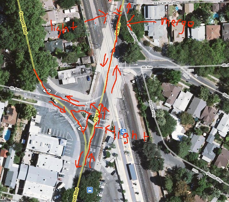 basically, they converted a one way system into two one way streets. Note that this is an extremely high volume street. Basically, we have a 4 lane 30 mph raod that used to go into a 2 lane one way (south) at 30 mph and a 3 lane one way at 35 mph (north -- 21st street). Now both are 2 lane two way streets at 25 mph. That would be annoying enough, except we got this intersection. Is it just be or does this intersection actually suck? What it used to be: http://maps.google.com/maps?client=...002639&t=h&z=19 And, why yes, that rail line is pretty active.
|
|
#
?
Oct 5, 2009 02:57
|
|

|
Cichlidae posted:...and a potential weave on I-83 eliminated by judicious use of a physical barrier between lanes. There's only one through lane on I-83 (ouch). And yet there's still weaving, caused by people coming from 283 North, merging on to 83, and trying to get off exit 45. And yes, 83 is only one lane in each direction passing through that interchange. Although if you look closely, there's a second effective lane heading southbound; exit on to Eisenhower Blvd, take the first exit to the right, and then follow the collector over back on to the interstate, completely bypassing the 83/283 interchange in the process. Another thing that bugs me about the whole area is that 83 ends a few miles north of there, where it intersects I-81, and 283 ends a few miles south where it hits the PA turnpike/I-76. It seems (to my non civil engineer self) that it would be more logical to end 83 at the interchange, annex the leftover section of 83 on to 283 and make that whole thing a loop off of either I-81 or I-76, since that's how it's functionally used. It would also serve to eliminate the confusion of I 283 intersecting with PA 283 (which also happens to be a pretty major route in the area) 2 miles south of the interchange. corgski fucked around with this message at 10:57 on Oct 5, 2009 |
|
#
?
Oct 5, 2009 10:53
|
|
|
nm posted:This is a pretty new change, one that not even google maps has it up. Well, the execution may be weird, but I can see why it was done. If you're heading West, with the previous design, the nearest crossings were quite far away. The new design cuts westbound travel time by a couple minutes and reduces congestion at the upstream and downstream crossings. Of course, at-grade rail crossings are always awful, especially when you have trains coming through every few minutes. Unfortunately, in an area as densely settled as this, it would be extremely hard to remove without some very expensive earthworks and retaining walls.
|
|
#
?
Oct 5, 2009 12:16
|
|
|
thelightguy posted:And yet there's still weaving, caused by people coming from 283 North, merging on to 83, and trying to get off exit 45. And yes, 83 is only one lane in each direction passing through that interchange. Although if you look closely, there's a second effective lane heading southbound; exit on to Eisenhower Blvd, take the first exit to the right, and then follow the collector over back on to the interstate, completely bypassing the 83/283 interchange in the process. I-83 makes two 90-degree turns in that area, which is hardly ideal for a 2-digit interstate. Of course, I can't complain, because I-84 has 8 in the Hartford area (yay for canceled freeways). As to I-283 and PA 283, that's something that definitely wouldn't happen here; Connecticut only allows one route per number, whether it's an interstate, federal, or a state road. Because of this, when I-84, I-86, and I-95 were built, the state routes with the same number were renumbered.
|
|
#
?
Oct 5, 2009 12:21
|
|
|
Cichlidae posted:That is a very interesting story. Do you know what sort of interchange was planned with it and the Motorvejen? Currently it's just a diamond, but that almost certainly wouldn't be enough for a freeway-freeway junction if it had been built. As to the speed issue, with the addition of a concrete barrier and re-striping down to narrower lanes (3-meter lanes could work quite well), speeds would drop and bicycle traffic would be protected from the cars.
|
|
#
?
Oct 5, 2009 16:30
|
|
|
Nesnej posted:In a somewhat similar fashion, I present you H�je Gladsaxe vej near Copenhagen Denmark. You've got a hell of a lot of bike/foot paths going on around there! I wish we were set up like that around here. What's with the field (a park?) southeast of H�je Gladsaxe vej (by R�dvadsvej) with the three big strips in it? Also, just to the left of that you've got an area with two soccer (football) fields in it and then a big oval field with a square in it - what's that? You also have a funny crop circle floating in the middle of your lake ") . What's with all the really long, thin, snaking buildings like the one near the intersection of Rolighesdvej and Falkoner Alle and then north of there? . What's with all the really long, thin, snaking buildings like the one near the intersection of Rolighesdvej and Falkoner Alle and then north of there?Don't mean to hijack the thread; Copenhagen just turned out to be full of fascinating oddities (to this American).
|
|
#
?
Oct 5, 2009 17:30
|
|
|
Cichlidae, Is there any truth to the rumour that Rt. 32 from I-84 Exit 68 to/through UConn is going to be widened to four lanes? It sounds crazy to me but apparently a lot of residents are talking about it. A guy I know who lives out there swears something is going on. The Route 6 fiasco gives me little reason to believe that a Rt. 32 expansion will ever be possible. The State will probably never move far beyond paying the State Troopers a bunch of overtime on move(in/out) and game days to manually control the stoplights, and we all know how fun that is for everybody. 
|
|
#
?
Oct 5, 2009 22:16
|
|
|
Winter Light posted:Cichlidae, It'd be much more useful to expand Route 195 than Route 32, though, wouldn't it? I haven't seen or heard of any expansion plans for Route 32, though, by the time I get things, the project has already gone through preliminary design. Given the tight curves, houses close to the road, and the fact that it runs alongside a river (the alignment hasn't really changed in 300 years), it would be tremendously expensive to expand Route 32. I'd definitely expand 195 instead, and even then, we're talking hundreds of millions of dollars. I'll do some sniffing and see what I can find. If you don't hear back from me about it, assume there's nothing planned. Keep in mind that any CT citizen can ask to see any state document, including emails, plans, preliminary stuff... just not the SLOSSS, because that's top secret. Oops, I've said too much! Edited to add: If they were going to expand it, SOMEONE would know for sure, because the state would be trying to buy his or her house. Cichlidae fucked around with this message at 22:59 on Oct 5, 2009 |
|
#
?
Oct 5, 2009 22:53
|
|
|
Cichlidae posted:It'd be much more useful to expand Route 195 than Route 32, though, wouldn't it? Dammit, I meant Rt. 195 and wrote Rt. 32. Ugh.
|
|
#
?
Oct 5, 2009 23:06
|
|
|
Winter Light posted:Dammit, I meant Rt. 195 and wrote Rt. 32. Ugh. That's been debated since the 1960s, with the state for the project and the town against it. ConnDOT tried to get 195 added to the National Highway System, which would have made it easier to expand, but the town blocked it. The town tried to make it scenic, preventing development, but the state blocked that. It's pretty much been a stalemate, and I doubt the state has plans to change that now that our budget is so bad. I'm sure some paranoia lingers due to the conflicts 30 years ago. There are some projects on 195, especially around UConn, but they're just minor things like streetscape improvements. That's not something that should draw a lot of complaints.
|
|
#
?
Oct 5, 2009 23:32
|
|
|
I have yet another question. They're grating the pavement around a bunch of Interstates around here right now. I notice that when they do, there are still lane markings. Do they grate the road and then repaint lane markings over the grating, or are they still there from before or something? They never look really very new, but that could be an artifact of putting the paint down on crappy grating.
|
|
#
?
Oct 7, 2009 01:49
|
|
|
Lucid Smog posted:I have yet another question. They're grating the pavement around a bunch of Interstates around here right now. I notice that when they do, there are still lane markings. Do they grate the road and then repaint lane markings over the grating, or are they still there from before or something? They never look really very new, but that could be an artifact of putting the paint down on crappy grating. PAVING 102 When pavement is milled, it can be just scored on the surface to help the next layer adhere, or it can go down several inches in depth. In the former case, the existing pavement markings are only partially removed. In the latter, there are several possibilities. I'll give you a quick refresher on how roads are paved here. The composition varies from state to state, but they're generally analogous. 1) The sub-base is laid out, usually an even layer of compacted gravel. 2) The base course of asphalt is spread out over the sub-base, rolled flat, and allowed to dry. 3) (Optional) The leveling course of asphalt is laid, basically a wedge that is thicker in the middle and thin at the edges, to ensure that water drains off the road. Again, rolled and allowed to harden. 4) Once a long stretch of road is complete, the wearing course is placed on top, rolled, left to harden, and then opened to traffic. On a small project, the whole process might just last a few days, and it's alright to let traffic drive over a bit of unmarked pavement for a short period. However, on larger projects, we need some kind of temporary pavement markings between stages 2, 3, and 4 so our good pal Granny McGee, driving her 40-year-old semitrailer back from the bar at 4 in the morning, doesn't forget she's on a road and plunge into some ditch filled with discarded bottles, used condoms, and rusted syringes. How this is done depends on the jurisdiction. For short periods (a few days), some special tape will generally work. Heck, we even have black tape to put over the old markings if we want to gently caress with you. For longer periods, we have a special kind of paint (but don't call it paint!) that works well for a couple months, max. Beyond that, we need to put down epoxy, the same stuff that goes on roads permanently. Now here's a problem: that epoxy isn't very sticky. When you put the final course of asphalt over it, well, the asphalt isn't going to stick to it. One trucker comes by and brakes a little hard, it'll rip off a little patch of asphalt on top of the old lane markings. A few months later, you have a pretty big hole forming in your new road. We can fix this by grinding down the epoxy before laying the final course, but that takes money. And hey, while I'm at it, another problem! How well do you think tape sticks to milled pavement? I'm sure you can guess. What happens when Granny McGee comes back from the hospital, has another bender, and ends up ripping up a thousand-foot stretch of tape, trailing it behind her like toilet paper on Admiral Pirk's shoe? Well, buddy, that's when I get some really pissed-off phone calls from the inspector asking why I let the contractor use tape. I hope that answers your question.
|
|
#
?
Oct 7, 2009 02:51
|
|
|

|
| # ? Apr 28, 2024 07:13 |
|
|
Cichlidae posted:PAVING 102 Yes, very thorough, thanks. I've never seen what I believe is tape. This must be the not-paint paint that they put down. The road looks to be milled down at least 2", and it's miles of pavement on an 8 lane interstate (I-695 in Maryland)... so it's not really a small job. How deep does the epoxy for normal lane markings go into the pavement surface, or is it all superficial?
|
|
#
?
Oct 7, 2009 14:28
|
|