Earwicker posted:I don't know, but I was mostly watching American media about it I would have thought they'd make a big deal out of it because that seems like something the media would do. FRIDAY THE 13th CRUISE CATASTROPHE! They were too busy calling it the "real life Titanic."  https://www.youtube.com/watch?v=6IFdWBPRrxo
|
|
 #
?
Sep 22, 2013 12:32
#
?
Sep 22, 2013 12:32
|
|


|

|
| # ? Apr 28, 2024 14:54 |
|
|
Michael Scott posted:Yep, if you use the "Report a Problem" link at your house location on Street View you can request a blur. I agree that it is a pretty silly concern for the homeowner and does elicit the Streisand Effect: http://en.wikipedia.org/wiki/Streisand_effect I think that depends on the area. For example if you look at Street View in most German cities, there is a house blurred out on almost any given block, so I doubt that's going to warrant any attention since it's so common there
|
|
#
?
Sep 22, 2013 22:13
|
|

|
What are these giant circles that look like bomb craters in The Netherlands near Rotterdam? https://maps.google.com/maps?hl=en&ll=51.931168,3.99117&spn=0.007158,0.021007&t=h&z=16
|
|
#
?
Sep 23, 2013 03:03
|
|

|
Retarded Pimp posted:What are these giant circles that look like bomb craters in The Netherlands near Rotterdam? Maybe bomb craters. Rotterdam was bombed by both sides in WW2. EDIT: zooming out I see a port complex, which was the main target of the bombing for the allies. wdarkk fucked around with this message at 03:23 on Sep 23, 2013 |
|
#
?
Sep 23, 2013 03:20
|
|

|
Those don't show up on the beach shot: or on Bing. I'm guessing it's some sort of "art" or somebody just loving around in the sand.
|
|
#
?
Sep 23, 2013 04:21
|
|

|
http://coastalcare.org/2010/12/land-reclamation-at-rotterdam-netherlands/ Probably has something to do with this land reclamation project.
|
|
#
?
Sep 23, 2013 04:35
|
|
|
MisterOblivious posted:Those don't show up on the beach shot: The Google Maps image is older than the other ones, in the Bing photo the field's soil has clearly been changed and the construction project's promo shot might be doctored to not make people think that the place could be littered with UXO. edit: actually, looking at the timeline the field is new. 2009:  2010:  2013:  Maybe something to do with drainage or irrigation? Nenonen fucked around with this message at 04:48 on Sep 23, 2013 |
|
#
?
Sep 23, 2013 04:43
|
|


|
The white stuff around the center circles doesn't immediately line up with anything I know about bomb craters, but that's definitely a place that would have some bomb craters.
|
|
#
?
Sep 23, 2013 04:46
|
|
|
wdarkk posted:The white stuff around the center circles doesn't immediately line up with anything I know about bomb craters, but that's definitely a place that would have some bomb craters. The white stuff look like hay bales in plastic wrapping to me.
|
|
#
?
Sep 23, 2013 04:49
|
|
|
It's newly-made ground, so bombing craters are only possible if there was some bombing campaign that happened between 2008 and now. Maybe some kind of excavation relating to the landfilling project.
|
|
#
?
Sep 23, 2013 04:50
|
|


|
Street view. Is that poop? https://maps.google.com/maps?q=kfc+...,156.12,,0,0.58
|
|
#
?
Sep 23, 2013 04:53
|
|

|
withak posted:It's newly-made ground, so bombing craters are only possible if there was some bombing campaign that happened between 2008 and now. Ah, I stand corrected.
|
|
#
?
Sep 23, 2013 04:54
|
|
|
mpyro posted:Street view. Is that poop? https://maps.google.com/maps?q=kfc+...,156.12,,0,0.58 If that's what your dumps look like, I might suggest you visit a doctor. It's a pear.
|
|
#
?
Sep 23, 2013 06:57
|
|

|
A pair of what?
|
|
#
?
Sep 23, 2013 07:00
|
|

|
withak posted:It's newly-made ground, so bombing craters are only possible if there was some bombing campaign that happened between 2008 and now. Clearly you never heard of the great Flemish raid of 2011! But yeah, they're marks left by the land reclaimation project for the port of Rotterdam. They are temorary drainage pits for leveling out the watertable. All the squigly lines around them are just dumped (truck)loads of sand, clay and sludge used to smooth out the surface later. Most likely they faded into the landscape already. Something else from the Netherlands: Birdseye view: http://binged.it/1bACEsi Streetview: http://goo.gl/maps/Vn7ZC The rebuild Dutch 17th century mechant fluyt, The Batavia (which met an unfortunate end on its maiden voyage four centuries ago.) And on the other side (still under construction) the famed Dutch 80 gun flagship The Zeven Provinci�n. Probably the most advanced and feared weapon of mass destruction of the later 1600s. Used to sink many an English bastard  . .Cool thing about these ships is that they're built entirely according to period methods, they're exact copies down to the last treenail. Def worth a visit if you're ever in the area.
|
|
#
?
Sep 23, 2013 07:48
|
|

|
Found some nice colors at the Reykjavik observatory. http://goo.gl/maps/fHr57
|
|
#
?
Sep 24, 2013 09:33
|
|

|
Detective Thompson posted:If that's what your dumps look like, I might suggest you visit a doctor. It's a nice pear, big as well, I'm surprised there is no frat boy in the street view giving it a feel.
|
|
#
?
Sep 24, 2013 09:49
|
|

|
Michael Scott posted:Yep, if you use the "Report a Problem" link at your house location on Street View you can request a blur. I agree that it is a pretty silly concern for the homeowner and does elicit the Streisand Effect: http://en.wikipedia.org/wiki/Streisand_effect Apparently the blurring is irreversible, too, as Google discards (or claims to discard, anyway) the original image. It's funny to see people on the Google Maps message boards demanding that Google unblur their house (after they requested it be blurred) because they're now trying to sell it or something and getting pissed because the Google folks say they can't restore the original.
|
|
#
?
Sep 29, 2013 05:06
|
|

|
Here's one for y'all ��not so much a "what" as a "why" New York/Quebec border There are a handful of spots like this where a road across the border was cut off (Google seems to have dispatched their Street View forces to them on the Canadian side). Anyone know when they were cut off? Pre- or post-9/11? E: Here's one a few miles to the east of the other (Street View on both sides of the border) Real Name Grover fucked around with this message at 19:53 on Oct 8, 2013 |
|
#
?
Oct 8, 2013 19:46
|
|

|
The neat thing here is you can see a granite stone marker that was probably set up by some border-defining expedition a long time ago. I don't know why the road does that, though, but the US/Canada border is a weird one.
|
|
#
?
Oct 8, 2013 19:56
|
|

|
There used to be plenty of uncontrolled crossing between the two countries; since the border moved a few times over the years, some people had houses built right on the border (IE, the living room in the states and the kitchen in Canada). Geodesics are hard, and it's a really loving long border. After 9/11, they really tightened up the border by cutting roads and adding fences, so now you have to at least get out of your car to get across the border. As we all know, terrorists really hate walking. (There's ground vibration detectors and all sorts of fancy stuff at chokepoints, but I wouldn't be surprised at all if there were plenty of places you could cross into the US undetected.)
|
|
#
?
Oct 8, 2013 20:03
|
|
|
Real Name Grover posted:
I have a vague recollection of the US government claiming that they were 'tightening' the Canadian border sometime around early 2002, that'd be my guess as to when a lot of these 'unmanned crossings' were gated off and left to grow over. It was around the same time as some random paranoia about al-Qaeda targetting bridges in the NW and NE metropolitan areas.
|
|
#
?
Oct 8, 2013 20:06
|
|
|
FrozenVent posted:After 9/11, they really tightened up the border by cutting roads and adding fences, so now you have to at least get out of your car to get across the border. As we all know, terrorists really hate walking. (There's ground vibration detectors and all sorts of fancy stuff at chokepoints, but I wouldn't be surprised at all if there were plenty of places you could cross into the US undetected.) When I was a teenager (in the PRE-9/11 WORLD) I went on a long canoeing trip up in the Boundary Waters Canoe Area which runs along the border between Minnesota and Ontario. The border there is marked essentially by a few posts scattered through the woods. That's when the border isn't running through the middle of a lake, which it often is. While I'm sure something was done during the 9/11 security frenzy, it would be really really hard to actually put any kind of real border control there, and I'm sure you can very easily cross back and forth there still.
|
|
#
?
Oct 8, 2013 20:46
|
|
|
Oh, of course. More than anything it has to be a pain in the rear end for the folks who live along the border who may have preferred going to, say, a grocery store in the other country.
|
|
#
?
Oct 8, 2013 20:47
|
|
|
Earwicker posted:When I was a teenager (in the PRE-9/11 WORLD) I went on a long canoeing trip up in the Boundary Waters Canoe Area which runs along the border between Minnesota and Ontario. The border there is marked essentially by a few posts scattered through the woods. That's when the border isn't running through the middle of a lake, which it often is. While I'm sure something was done during the 9/11 security frenzy, it would be really really hard to actually put any kind of real border control there, and I'm sure you can very easily cross back and forth there still. Just out of curiosity what group did you take this trip with Earwicker?
|
|
#
?
Oct 8, 2013 21:19
|
|


|
DandyLion posted:Just out of curiosity what group did you take this trip with Earwicker? It was a group associated with the Concordia Language Villages called "Les Voyageurs". It's mainly based near Bemidji (on Turtle River Lake) but in the program I did we did an extended two week trip in the Boundary Waters. It was awesome.
|
|
#
?
Oct 8, 2013 22:27
|
|
|
MisterOblivious posted:While we're on the subject of Cold War era military installations this place now officially exists. big business sloth posted:The neat thing here is you can see a granite stone marker that was probably set up by some border-defining expedition a long time ago. https://www.youtube.com/watch?v=qMkYlIA7mgw
|
|
#
?
Oct 8, 2013 22:43
|
|


|
I was gonna link that!
|
|
#
?
Oct 8, 2013 22:45
|
|
|
If you guys want to see a really bizarre border there is an area of the Netherlands/Belgian border that is an absolute mess. Like a bunch tiny little plots that belong to one country entirely embedded enside the other and vice versa.
|
|
#
?
Oct 8, 2013 23:01
|
|
|
Earwicker posted:If you guys want to see a really bizarre border there is an area of the Netherlands/Belgian border that is an absolute mess. Like a bunch tiny little plots that belong to one country entirely embedded enside the other and vice versa. A good place to look is Baarle. There used to be a pub there with a pool table on the BE-NL border
|
|
#
?
Oct 8, 2013 23:25
|
|

|
Any idea what these boxy things are around these coords? (0038.528925, -0121.020154)
|
|
#
?
Oct 21, 2013 02:02
|
|


|
Elendil004 posted:Any idea what these boxy things are around these coords? Those are clearly mobile biological weapons laboratories. Here�s a schematic.
|
|
#
?
Oct 21, 2013 02:20
|
|

|
Maybe some kind of hillbilly shack.
|
|
#
?
Oct 21, 2013 02:35
|
|
|
jisforjosh posted:Not that strange because what it is, is known, but it's pretty cool that Hashima Island (coal mining island city that Mitsubishi built up, later abandoned) has street views throughout. This is where part of Skyfall was filmed Edit: Never mind. If I had done one more minute of searching before posting I would have seen that they built sets based off the island. They never actually filmed there. Tainen fucked around with this message at 05:59 on Oct 21, 2013 |
|
#
?
Oct 21, 2013 05:57
|
|

Real Name Grover posted:Here's one for y'all ��not so much a "what" as a "why" This is common on the west coast too. I remember my mom and I accidentally driving into Washington state when I was young, only realizing it because the street signs were a different colour, but I don't think you can do it anymore. You have to have a passport on you by law now thanks to 9/11 too. In Vancouver, which hugs the border, it's understood only certain streets are official crossings, 4-5 total, and they often all have hour+ line-ups. My brother is a border guard and can be sent to any of them to work. Here's the border in Point Roberts, WA, a strange peninsula only accessible through Vancouver by land. 
|
|
|
#
?
Oct 21, 2013 06:35
|
|
|
Elendil004 posted:Any idea what these boxy things are around these coords? leidend posted:This is common on the west coast too. I remember my mom and I accidentally driving into Washington state when I was young, only realizing it because the street signs were a different colour, but I don't think you can do it anymore. You have to have a passport on you by law now thanks to 9/11 too.
|
|
#
?
Oct 21, 2013 09:31
|
|

|
Elendil004 posted:Any idea what these boxy things are around these coords? 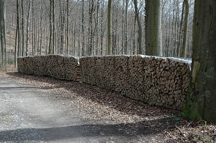 You can see those everywhere in the woods in Germany. No idea if they are common in America.
|
|
#
?
Oct 21, 2013 13:09
|
|

|
tonberrytoby posted:Might be a stack of wood drying like this: Yup, absolutely common in America, I have one in my backyard right now.
|
|
#
?
Oct 21, 2013 13:13
|
|
|
 No need to identify this strange thing on google maps, local police in Oregon already identified it as a backyard pot farm and Took Steps. http://arstechnica.com/business/2013/10/google-earth-narcs-on-an-oregonian-marijuana-grower/
|
|
#
?
Oct 22, 2013 17:12
|
|
|

|
| # ? Apr 28, 2024 14:54 |
|
|
Thought I'd do a flyover of a nudist resort: https://maps.google.com/maps?q=plea...lorida&t=h&z=20 I think I see someone in a lounge chair, sweet! (not far from the American Nudist Research Library...) Subliminal Sauce fucked around with this message at 20:52 on Oct 22, 2013 |
|
|
#
?
Oct 22, 2013 18:37
|
|