|
Saint Fu posted:Evolution Lake gently caress. I've always wanted to hike the Evolution Region.
|
 #
?
Sep 27, 2014 02:56
#
?
Sep 27, 2014 02:56
|
|


|

|
| # ? May 2, 2024 08:16 |
|
|
Thanks everyone, hope you all don't mind a few more photo posts. R0002342 by spf3million, on Flickr Upper Rae Lake  R0002772 by spf3million, on Flickr Bubb's Creek  R0002821 by spf3million, on Flickr 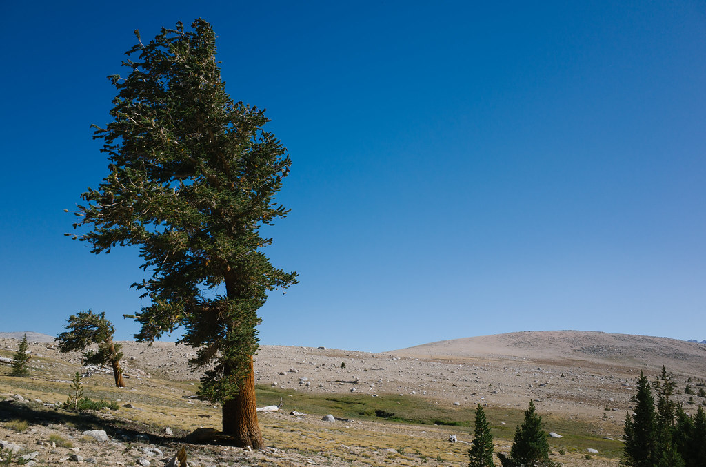 R0002897 by spf3million, on Flickr Morning hike up Whitney  R0002962 by spf3million, on Flickr
|
|
#
?
Sep 28, 2014 16:35
|
|

|
Here's a few shots from the Lost Coast. And my bruised rib is almost entirely recovered! Areas are often flooded at high tide:  Lots and lots of walking on beaches that all look like this:  Here are some birds 
|
|
#
?
Sep 28, 2014 19:21
|
|


|
Picnic Princess posted:I loving love the program I'm in. We did a last minute field trip to go to a nearby conservation area with a seasoned elk bugler to watch and listen to the rut. Listening to those animals is magical. We only spotted them after sunset, in silhouette on a nearby hill, but it was totally worth it. I really want to make going out and listening to elk a regular tradition in my life. I lived near an elk farm for years when I was a kid. It never really stops being a surreal and special sound.
|
|
#
?
Sep 29, 2014 01:33
|
|

|
Unreal weather this weekend in NH - 75-80 degrees, but the leaves are turning. Perfect time to do an Isolation overnight. Southern Presis and Washington.  LEAF PEEPIN'  Unfortunately the unironic peepers are starting to migrate up, saw loads of people just taking pictures of trees on the side of the Kanc. Also driving through Conway/North Conway literally added an hour to the trip up due to traffic, that was poor planning on my part though.
|
|
#
?
Sep 29, 2014 04:02
|
|


|
Are the crowds and traffic bad in southern NH during the weekdays? I'm thinking of hiking in Pisgah or something like that a week from Thursday.
|
|
#
?
Sep 29, 2014 04:17
|
|

|
Generally you're safe hiking anywhere on weekdays/non-holidays, with the possible exception of Fridays, and since there aren't any mountains in Pisgah (and it's pretty large) you'd probably be OK... however I haven't actually been there so maybe someone more knowledgeable can chime in.
|
|
#
?
Sep 29, 2014 05:02
|
|
|
I've only ever noticed the traffic get bad for Fall north of Rt4, so Concord out to the seacoast.
|
|
#
?
Sep 29, 2014 05:13
|
|


|
Weekdays are generally fine; it's weekends that the massholes flood in. Did you ever hit Monadnock, Time Cowboy?
|
|
#
?
Sep 29, 2014 05:43
|
|


|
Yes, but I made a fiasco out of it. I was 2/3 of the way to the summit when I realized my wallet was missing. So I had to drag my fat rear end all the way down the White Dot looking for it -- and that trail is way more fun going up than going down. Eventually I did find my wallet, which had been in the car the whole frigging time, but I was too exhausted to do anything but drive all the way home. I was incredibly sore for three days after that. I need to get back to the gym.
|
|
#
?
Sep 29, 2014 11:58
|
|
|
I think we need a goon excursion. It sounds like there are a lot more locals than I though. We can fill our camelbacks with Mountain Dew, and our packs with Cheetos. Fake edit: I just pictured what havok that would wreak on my digestive system while hiking.
|
|
#
?
Sep 29, 2014 13:35
|
|
|
Time Cowboy posted:Yes, but I made a fiasco out of it. I was 2/3 of the way to the summit when I realized my wallet was missing. So I had to drag my fat rear end all the way down the White Dot looking for it -- and that trail is way more fun going up than going down. Eventually I did find my wallet, which had been in the car the whole frigging time, but I was too exhausted to do anything but drive all the way home. I was incredibly sore for three days after that. Ah, that does indeed suck. It doesn't help that the dot is probably the lamest trail on the mountain.
|
|
#
?
Sep 29, 2014 14:00
|
|
|
I'll come back next year for the Pumpelly. I can't let a summit elude me because of my own incompetence.
|
|
#
?
Sep 29, 2014 14:13
|
|
|
I want to plan an October weekend trip but my dad still hasn't mailed back my stove, knife, hiking poles, etc from my last trip 
|
|
#
?
Sep 29, 2014 15:14
|
|

|
Going to the enchantment lakes this week! Anyone know if it's reasonable to try to fish at Stuart lake or Lake Wenatchee?
|
|
#
?
Sep 29, 2014 17:06
|
|

|
I'm not much of a fisherman but I think you'd have better luck on the Wenatchee river. Assuming you're camping up pretty high be prepared for some cool temps.
|
|
#
?
Sep 29, 2014 17:46
|
|

|
mastershakeman posted:Going to the enchantment lakes this week! Anyone know if it's reasonable to try to fish at Stuart lake or Lake Wenatchee? Have fun, be safe. Stay warm. When I was up there last month, it was pretty cold at night for being in the high 80s during the day. One night was about 30�f. The rest were between 30-40�. I can only imagine where the temps would be now.
|
|
#
?
Sep 29, 2014 20:36
|
|
|
Verman posted:Have fun, be safe. Stay warm. Gotcha. I think we'll be camping at around 5000 feet so I'm right on the range of bringing my 0 degree bag vs my 30 degree one. Probably best to do the 0 degree but use my small uninsulated sleeping pad instead of the huge 90s thermarest I have. I'm kind of tempted just to risk the fines for camping in the wrong zone in the Enchantments, mainly because I can't find any maps that point out where the heck campsites are located at. I've planned to just camp in our zone and day hike over the Asgard Pass and down into the actual Enchantment Lakes themselves, then dayhike back out, but don't really know where we can base from to do that.
|
|
#
?
Sep 29, 2014 22:45
|
|
|
Rangers frequently check for permits up there, also it really is a fragile ecosystem, they are instituted for a reason. Where's your permit at? In the core zone, the campsites are petty obvious places along the trail, and there's a secret spot behind Heart Lake. I was up there this time last year and it was windy and into the 20's at night. But there were baby goats!
|
|
#
?
Sep 30, 2014 01:56
|
|

|
I know this thread seems to mostly center on the West and it's plethora of gorgeous mountainous vistas but had anyone here been to Isle Royale the last few years? I haven't been since 2000 an I'm heading up there next summer. I just wanted to know if there's been an explosion in popularity or whether one ferry line is better than another. I've been through Copper Harbor twice and I'm wondering if the extra two hours is worth it to skip the Keewenaw scenery. Also anything else you want to add. Thanks kind Goons.
|
|
#
?
Sep 30, 2014 03:52
|
|

|
I think Mastershakeman might have some experience up there if I remember correctly. Maybe it was the Apostle islands.
|
|
#
?
Sep 30, 2014 04:15
|
|
|
I was there in august for ten days. There definitely hasn't been an explosion in popularity - they're still seeing ~15,000 people a year IIRC. The boats all have upsides/downsides. If you take the ranger from Houghton it only runs twice a week and it's about 6 hours each way. Benefits are that it's bigger so there's fewer issues with bad weather (the Queen can be a vomitfest) and it's less driving. If you take the Queen from Copper Harbor it runs daily and gets there earlier - You can be on the trail by 11am instead of 3pm. It's generally considered the pro choice for maximizing your flexibility, as long as you don't mind having to be ready to go real early. Downsides is that you might end up barfing your face off. We took the ranger because we were in Houghton already and it was easier logistics in the morning. If you dont get to the keweenaw much, I'd suggest taking the queen and seeing the peninsula. There's a new restauraunt/inn (well they're 7 yrs old) in eagle river called Fitzgerald's and its a 100% pro choice for grub and a shower on your way back from the island. Best meat, beer, whiskey, and view in the UP bar none. Rooms are like 100bux a night and the food and booze is worth every penny. As far as time on the island goes, the shelter thing is a little bit weird at first but becomes awesome. If you're there at peak season you want to be arriving at your campsite around noon to 1pm to get a shelter - its worth it especially in the rain. Threemile is ok but daisy farm is worth skipping, since it's like camping in an RV park with all the people there. However, if you can be there saturday night for the wolf/moose talks DO IT. McCargoe is awesome, Moskey basin is awesome (make a point of getting here early to get a sweet shelter, they're incredibly situated right on the water), chippewa harbor is awesome but out of the way. Avoid chickenbone lake. West chickenbone seems mediocre but east chickenbone has poo poo water access (like a mile of bushwhacking) and its bug central. We never got farther south/west than that but word is that it gets progressively more rugged and isolated and I don't doubt it. Bring binoculars, and maybe a bird book. If you're not doing a time-constrained island-crossing trek don't feel bad about taking it easy. Spend a couple days in one spot and poke around in the woods, off trail a ways. Check out the mines at McCargoe - we spent two nights there and did a (super easy) dayhike out and it was well worth it. I won't be going back without at least minimal fishing gear, and probably not without a boat of some kind. If you haven't, learn up on identifying wild berries: thimbleberries, raspberries, and blueberries should be blowing up around late july through august. I have never eaten such obscene quantities of blueberries as I have on isle royale. Isle Royale is certainly not out-west mountain-vista hiking but once you get into the swing of things on the island it's got a special magic for sure. I'm certainly going to be going back over and over again - it's an incredible place. Edit: Some pictures 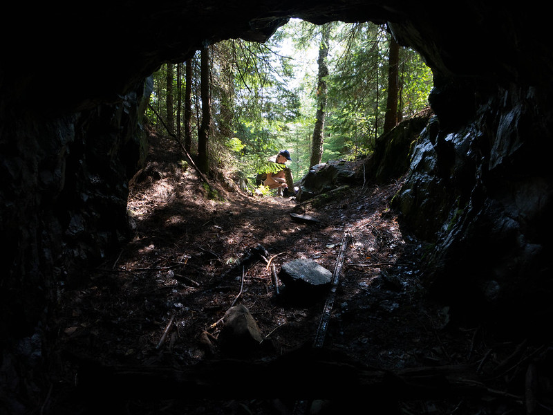 Minong Mine, 2014 by wallofinsanity, on Flickr 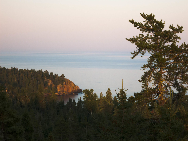 Chippewa Harbor, 2014 by wallofinsanity, on Flickr 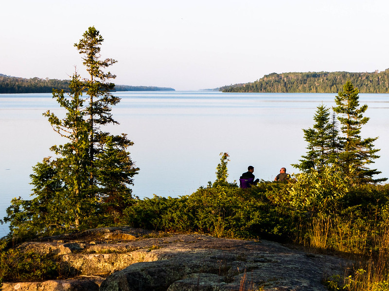 Moskey Basin, 2014 by wallofinsanity, on Flickr Spime Wrangler fucked around with this message at 06:12 on Sep 30, 2014 |
|
#
?
Sep 30, 2014 06:00
|
|


|
mastershakeman posted:Gotcha. I think we'll be camping at around 5000 feet so I'm right on the range of bringing my 0 degree bag vs my 30 degree one. Probably best to do the 0 degree but use my small uninsulated sleeping pad instead of the huge 90s thermarest I have. Don't be a dumbshit, the Enchantments are full of snobby 206ers more than willing to narc on you. You'll get banned for something like 2 years from a bunch of FS related poo poo. Have you tried googling for something like enchantments campsites? This isn't very difficult and the area is extremely well documented. Why not just do a loop? I know tons of people that just through hike the enchantments in a day (not my idea of fun). Edit: Literally the first result on google for enchantments campsites is an amazingly well done site/documentation of all the camping/toilets on the hike. n8r fucked around with this message at 06:43 on Sep 30, 2014 |
|
#
?
Sep 30, 2014 06:35
|
|
|
One more from the JMT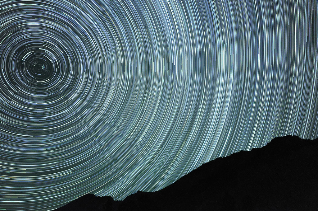 JMT Star Trails 2.3 by spf3million, on Flickr
|
|
#
?
Sep 30, 2014 11:46
|
|
|
Discomancer posted:Rangers frequently check for permits up there, also it really is a fragile ecosystem, they are instituted for a reason. Where's your permit at? In the core zone, the campsites are petty obvious places along the trail, and there's a secret spot behind Heart Lake. I was up there this time last year and it was windy and into the 20's at night. But there were baby goats! Our permit is stuart lake zone. I only applied for the core zone on different weekends and struck out for the third year running. However two of my friends applied to random zones because they were more focused on going to octoberfest in Leavenworth on the same trip, and both won permits for stuart. So I'm hoping there's a campsite near the stuart/colchuk border that we can dayhike from but it's really hard to tell from maps.
|
|
#
?
Sep 30, 2014 14:22
|
|
|
n8r posted:Don't be a dumbshit, the Enchantments are full of snobby 206ers more than willing to narc on you. You'll get banned for something like 2 years from a bunch of FS related poo poo. Have you tried googling for something like enchantments campsites? This isn't very difficult and the area is extremely well documented. Why not just do a loop? I know tons of people that just through hike the enchantments in a day (not my idea of fun). Can you link what I'm looking at? All the maps/guides I found were restricted to the main trail and had minimal info on the stuart zone trail. Also, a two year ban? Holy poo poo I figured it was just a fine that we could split the cost of. mastershakeman fucked around with this message at 14:30 on Sep 30, 2014 |
|
#
?
Sep 30, 2014 14:23
|
|
|
Nateron posted:I know this thread seems to mostly center on the West and it's plethora of gorgeous mountainous vistas but had anyone here been to Isle Royale the last few years? If you've hiked it already I'd highly suggest renting a sea kayak and exploring that way. The kayaking is absolutely amazing on the north side, and if you really want to go wild you can do a loop through the interior lakes like chickenbone. However, portgaging for that was horrible.
|
|
#
?
Sep 30, 2014 14:27
|
|
|
mastershakeman posted:Our permit is stuart lake zone. I only applied for the core zone on different weekends and struck out for the third year running. However two of my friends applied to random zones because they were more focused on going to octoberfest in Leavenworth on the same trip, and both won permits for stuart.
|
|
#
?
Sep 30, 2014 16:04
|
|
|
mastershakeman posted:Also, a two year ban? Holy poo poo I figured it was just a fine that we could split the cost of. Fines mean nothing, as you have just demonstrated.
|
|
#
?
Sep 30, 2014 16:15
|
|
|
Discomancer posted:If it makes you feel any better, I've lost the lottery 8 times, the only time I've gone is on someone else's permit. I've struck out three times running myself. Hopefully next year I will get it. Is it random every year or do your chances go up the longer you try like some hunting permits work? I've always been interested in Isle Royale after reading all the wolve/moose studies but I never thought to try and kayak it before. Might have to make that my big trip for next year if I don't get my Enchantments permit again.
|
|
#
?
Sep 30, 2014 16:27
|
|

|
BaseballPCHiker posted:I've struck out three times running myself. Hopefully next year I will get it. Is it random every year or do your chances go up the longer you try like some hunting permits work? If you're real confident you don't even need to take the ferry, just paddle over from thunder bay. I actually met a 60 year old couple that did that in an open canoe, which was insane. My trip was the calmest I'd ever seen Superior but I can imagine some kayak trips going nowhere when twenty foot waves are coming.
|
|
#
?
Sep 30, 2014 16:30
|
|
|
Spime Wrangler posted:I was there in august for ten days. There definitely hasn't been an explosion in popularity - they're still seeing ~15,000 people a year IIRC. Thanks for the reply. I've backpacked it once and canoed it once, both times leaving on the Queen, sounds like it's much the same as I left it. Have they built any "new" shelters? I seem to recall a few at at each site but we're not ones to play the shelter game. McCargoe is on the short list, though I think we're gonna pound out the Greenstone/Minong instead of piecemealing it like we did last time. Also Chippewa is gorgeous. Went there when we canoed it. Though the portage from Ritchie to Chippewa is a back breaker. Especially with a flat back motor mount aluminum canoe. Never again. Fishing was hit or miss when I went hiking but having a canoe was like cheating. Tons of hits and catches. Lake Ritchie was especially fun. I'll probably bring a small break down rod just cause. Have they taken any of the boat docks out? I hear there was talk of removing some of them. Either way thanks for the info.
|
|
#
?
Sep 30, 2014 16:54
|
|
|
mastershakeman posted:If you've hiked it already I'd highly suggest renting a sea kayak and exploring that way. The kayaking is absolutely amazing on the north side, and if you really want to go wild you can do a loop through the interior lakes like chickenbone. However, portgaging for that was horrible. I've canoed Rock Harbor, some of the inland lakes but my sea kayaking skills don't rate a north shore trip. Besides after dropping money into whitewater boating I think the wife would divorce me if I bought/talked about other kayaks. Still something I'd love to do. What were the temps like when you were up there?
|
|
#
?
Sep 30, 2014 16:58
|
|
|
Nateron posted:I've canoed Rock Harbor, some of the inland lakes but my sea kayaking skills don't rate a north shore trip. Besides after dropping money into whitewater boating I think the wife would divorce me if I bought/talked about other kayaks. 80 air, 40 water, early July. I had a paddling suit and also wetsuit in case of storms but overheated so bad in them I ended up in a tshirt doing the north side after all the portgages. It's actually best to go real early or late in the season so that the temps are closer together. I don't think you'd need a drysuit unless you were there really early. And yeah, fishing on Lake Ritchie was a joke. I didn't even bother fishing from the kayak, just off the shore line, but fish were throwing themselves out of the water to get my lure between casts. On the downside, my friend and I got covered in leeches and his tent still has a bunch of bloodstains on it from pulling them off later at night. Here's where I went. Had to hike each portage 5 times - there and back with one kayak, there and back with the next, then there with the gear. Next time I need to bring a wheeled cart, or just not do the interior lakes. The island has a lot more terrain than I expected too.  vvv Circumnavigating the island would be amazing but also incredibly tiring. I can't imagine having to deal with any actual weather on the north side, either. mastershakeman fucked around with this message at 21:47 on Sep 30, 2014 |
|
#
?
Sep 30, 2014 17:20
|
|
|
Nateron posted:Have they taken any of the boat docks out? I hear there was talk of removing some of them. No worries! I don't think there's been many additions recently - all the shelters we stayed in had graffiti going back decades. The dock at Moskey is a little messed up at the very end, but is still fully functional. I don't know how long that will be the case, though, since they've had big budget cuts and have even had to shut down a couple park ranger posts recently. The one on Amygdaloid island is gone at least. We were scoping those portages for our next trip, and figured that (time permitting) it would be better to just go through Siskiwit instead of straight into Chippewa. That's a long-rear end way to carry a boat. However any weather would make me want to avoid the big lake in a canoe. Speaking of boats, one of our friends recently did another kayak trip out there. As in, he kayaked out to the island, around it, and back. From the Keweenaw. Solo. He made the ~50 mile crossing in 9 hours each way. Simply ridiculous.
|
|
#
?
Sep 30, 2014 17:33
|
|
|
mastershakeman posted:Can you link what I'm looking at? All the maps/guides I found were restricted to the main trail and had minimal info on the stuart zone trail. First result on google for enchantments campsites: http://www.everytrail.com/guide/the-enchantments/map Or just refer to the USGS 7.5 http://caltopo.com/map.html#ll=47.49068,-120.83151&z=14&b=t The two year ban is for trying to cheat the lottery actually (by having multiple members of your party enter it). I wouldn't be surprised if you got caught in the wrong spot it's worse. If I were you I'd probably stick to the Colchuck lake side of Aasgard Pass. Day hike up to the top, take in the view and hang out then turn around. Going up and over twice will be rather unpleasant even with just daypack gear. I'm a little negative on the Enchanments because it's a huge loving hassle and there are tons of places around here that are as cool or nearly as cool.
|
|
#
?
Sep 30, 2014 22:11
|
|
|
n8r posted:First result on google for enchantments campsites: Sorry to say but I'm still not seeing where the campsites on the Stuart Lake zone are on that. Oh well, we'll figure it out when we're there. I didn't even realize we could get fined for having multiple members of the party enter the lottery  And yeah, I can see why you think it's a hassle to deal with the area. It actually helps my group - they're all so busy with work and other commitments that we had to have something incredibly hard to do to get them to stick to the schedule - every other trip falls apart last minute because of wedding invites, work demands, etc. that they won't say no to because the trip isn't special enough. I ended up doing most of my camping alone due to that.
|
|
#
?
Oct 1, 2014 03:24
|
|
|
Yes that site doesn't include the Stuart lake zone like it does the core zone. I'd wager once you get to Stuart it will be plainly obvious where the campsites are. You're over thinking this at this point. Do keep in mind that loving around with FS regs like permits and such are so not worth it. The only one worth loving with is parking on the other sign that says you have to have some BS parking permit. I hate that parking permit scheme they've got going on both within the state and federally.
|
|
#
?
Oct 1, 2014 04:40
|
|
|
I've booked myself (and others) for 4 nights in Zion National Park in late March, early April. I am pretty new to camping, I've only done a car camping trip in Joshua Tree, and just recently did a 3 night on Channel Islands in August. I've got a few questions about what I should expect coming up: I saw some of the pictures of Angel's Landing, and the precarious nature of the last half mile to the summit. Are trail runners, or those Minimus style shoes in the OP appropriate for that last leg, or am I going to want a hiking shoe? Also, if I'm clammy hands-y by nature, am I going to want some gloves for hanging onto that chain? I would love to be able to do the Narrows, but I am aware that it might be impossible, and even if it isn't closed, a terrible idea due to water levels and temperature. However, if I get really lucky with conditions, what kind of bottoms would be appropriate for them? How mm thick wet suit style pants would I actually be looking at, and do those kind of pants actually lend themselves well to hiking at the same time? I'm going to be solid on tent and sleeping bag situation, I will acquire temperature appropriate gear, and I'm aware of Utah's blue laws on ABW. Is there anything else I should be looking out for, something not as commonly known that I might not know to look for? I booked 2 sites at Watchman, loop D.
|
|
#
?
Oct 1, 2014 21:30
|
|

|

|
| # ? May 2, 2024 08:16 |
|
|
Noah posted:I've booked myself (and others) for 4 nights in Zion National Park in late March, early April. I am pretty new to camping, I've only done a car camping trip in Joshua Tree, and just recently did a 3 night on Channel Islands in August. I've got a few questions about what I should expect coming up: I just did Angels Landing for the 4th time, I think. It never gets old, but the crowds do. The hike is pretty easy once you're on the rock fin, hence the swarms of people. Before that, it's a mostly paved switchback trail which will hurt a lot more on the way down. Neither section taxes your shoes and I've always preferred lighter/minimal shoes in these situations. Grippy footwear is always good, especially if you're terrified of heights. You do not need gloves and you probably won't even use all of the chains unless you're completely terrified of heights. From the top, 5 days ago: 
|
|
#
?
Oct 1, 2014 22:59
|
|