


|
What's the reasoning for airport road signs being white-on-black?
|
 #
?
Oct 6, 2015 14:23
#
?
Oct 6, 2015 14:23
|
|


|

|
| # ? Apr 19, 2024 10:46 |
|
|
dupersaurus posted:What's the reasoning for airport road signs being white-on-black? Do you mean guide signs to help point the route to the airport out to motorists? A quick google image search tells me that they are overwhelmingly not white on black, with the exception of Heathrow signs, which is probably a branding thing to help them stand out. This is probably the reason why local signs would do something similar, to help you find what you're looking for by standing out easily at a glance. Runway signs appear to be black on yellow, or black/white on red.
|
|
#
?
Oct 6, 2015 15:55
|
|
|
Devor posted:Do you mean guide signs to help point the route to the airport out to motorists? A quick google image search tells me that they are overwhelmingly not white on black, with the exception of Heathrow signs, which is probably a branding thing to help them stand out. This is probably the reason why local signs would do something similar, to help you find what you're looking for by standing out easily at a glance. Highway signs. With my sample size of airports I can recall (n=2, IAD and RDU), the signs for airport facilities (on airport grounds, at least) are white-on-black. RDU IAD DCA BWI Doesn't look like it's universal, but it does seem common.
|
|
#
?
Oct 6, 2015 16:46
|
|
|
dupersaurus posted:What's the reasoning for airport road signs being white-on-black? Airport grounds are typically outside of regular DOT road management, so they can do whatever they want with signage. As Devor said, a lot of it is branding (I loved the old, brown signage used at Newark) and often matches the wayfinding signage inside the terminals themselves.
|
|
#
?
Oct 6, 2015 18:00
|
|


|
AMS, DUS, DXB. Only Dubai has signage that's the same as everything else, Schiphol and D�sseldorf use bespoke shite. e: come to think of it, outside of the US airports are often private ventures who can do whatever the gently caress they want, but apparently that goes for road signs inside the US as well. Koesj fucked around with this message at 18:38 on Oct 6, 2015 |
|
#
?
Oct 6, 2015 18:35
|
|

|
Fun fact: the signage in Schiphol airport Amsterdam is designed by the same guy who designed it for the New York airports (at least for the indoor areas). That's why those airports look so similar. And many other places. Airports all over the world (even fictional ones: 'The Terminal'), museums, large office buildings, etc. It's a Dutch visual designer called Paul Mijksenaar and he received several awards for making signage that's extremely clear and easy to use. https://en.wikipedia.org/wiki/Paul_Mijksenaar Here's his site, see if you recognize any of his projects. http://www.mijksenaar.com/project-overview/
|
|
#
?
Oct 6, 2015 18:59
|
|

|
Oh crap so that's why HIA's signage feels about 1000x better thought out than Dubai's.
|
|
#
?
Oct 6, 2015 19:16
|
|
|
I decided to publish it in the current config.  http://steamcommunity.com/sharedfiles/filedetails/?id=531001229 But I will try building the new config later. http://steamcommunity.com/sharedfiles/filedetails/?id=531001229 But I will try building the new config later.
|
|
#
?
Oct 7, 2015 01:34
|
|

|
Carbon dioxide posted:Fun fact: the signage in Schiphol airport Amsterdam is designed by the same guy who designed it for the New York airports (at least for the indoor areas). That's why those airports look so similar. And many other places. Airports all over the world (even fictional ones: 'The Terminal'), museums, large office buildings, etc. It's a Dutch visual designer called Paul Mijksenaar and he received several awards for making signage that's extremely clear and easy to use.
|
|
#
?
Oct 7, 2015 01:52
|
|

|
Most airport signage is designed around branding and/or some kind of wayfinding convention. Down here in the Sunshine State, there are two major signage conventions at play, depending on airport type. The Airside-Landside airports use two North/South "side" colors for their main landside terminal and a generic pathfinding color. Here in Tampa, we use black, blue and red at TPA, with blue representing airsides A/F and red representing airsides C/D/E. Black signs refer to parking and exits. Orlando does the same thing at MCO, but with Brown, Teal and Coral. Atlanta-Hartsfield is also in the black/red/blue club. At the LAX-esque multi-terminal airports, things are typically organized by letter/number/color combinations, the same as many metro lines are distinguished from each other... though Miami recently moved to a modified version of Tampa's color scheme that uses additional colors for each terminal and exit route. GWB in Houston is the same way. Palm Beach does the same, but with MUTCD-compliant signs instead of the black stuff for general signage. The exception is Jacksonville, which lives in its own little blue world with blue Disney-esque signage. P.S.: TPA is an awesome airport. Just saying. Edit: Speaking of Tampa, Southbound I-275 construction is complete. Lane #4 opens next week.
Varance fucked around with this message at 07:18 on Oct 8, 2015 |
|
#
?
Oct 8, 2015 06:15
|
|

|
Varance posted:P.S.: TPA is an awesome airport. Just saying. But man, every time I fly to my parents I make sure to look for the bronze hanging pelicans (they're there to distract you if you're afraid of heights!). And I loooove the "maximum walking distance before rest" idea (escalator, shuttle, etc). And free wifi ... quote:Edit: Speaking of Tampa, Southbound I-275 construction is complete. Lane #4 opens next week. phongn fucked around with this message at 17:23 on Oct 8, 2015 |
|
#
?
Oct 8, 2015 17:19
|
|

|
Cichlidae posted:Since we don't build bridges out of platinum, salt water (or any water with electrolytes) is going to corrode metal; it's just a question of how long it takes. Your friend might be happy to know that bridges are routinely inspected. A lot of them are in HORRIBLE shape, yes, but they're almost always caught before they collapse. Obviously don't drive over any bridges that are visibly messed up. Cichlidae, have you heard about the Rouge River Bridge in Michigan? Cichlidae posted:
Even though the water is initially going through a culvert, this kind of illustrates what will happen
|
|
#
?
Oct 8, 2015 17:48
|
|

|
Speaking of TPA... https://www.youtube.com/watch?v=nTylqcX5sPU https://www.youtube.com/watch?v=pk0c3I0WAJY That looks pretty drat nice, and getting rid of those rental-car shuttles is a step in the right direction, I think.
|
|
#
?
Oct 8, 2015 18:06
|
|

|
sleepy.eyes posted:That looks pretty drat nice, and getting rid of those rental-car shuttles is a step in the right direction, I think. Centralizing rental car facilities seems to be a trend, and a great one at that. O'Hare recently started construction on their new rental car facility/rail station, but it seems like every airport I've flown to in the past five years has one or is planning one.
|
|
#
?
Oct 9, 2015 19:11
|
|
|
sleepy.eyes posted:Speaking of TPA... I remember when Airside F was the new shininess and now it just looks dated. Long memories of the original-four airsides, too, with coin-op, OTA B&W TVs. And the 'building on stilts' Airside E. And the old rich-and-dark toned inside. Good times.
|
|
#
?
Oct 9, 2015 20:18
|
|
|
All of TPA's airsides are going to be renovated, in sequence, starting with a complete rotation of all of the concessions and the construction of the Economy Parking/CONRAC people mover. Airside D will eventually be rebuilt (doesn't exist right now), after which the airsides will be rotated in and out. There are also plans for a third north-south runway on the far west side. Airside B is now international holding, while the former airside shuttle area will lead out to the CONRAC people mover. Once the CONRAC peoplemover is done, you can park in the economy garage or dropoff a rental car and be at the TSA checkpoint for your flight in less than 10 mins. About half of the concessions going in are some of our best local chains (Bavaro's, Columbia, PDQ, Cigar City, Ducky's, Buddy Brew, Goody Goody, Burger 21, etc.). New concessions map: http://www.tampaairport.com/terminal-and-airside-maps P.S.: Airside C will still have its microbrewery, while the airport brews will be expanded to all airsides via the various local bars. Varance fucked around with this message at 23:53 on Oct 10, 2015 |
|
#
?
Oct 10, 2015 22:25
|
|
|
drgnwr1 posted:Cichlidae, have you heard about the Rouge River Bridge in Michigan? I hadn't heard about it, but holes like that are pretty common. The Aetna Viaduct in Hartford looks like swiss cheese when you do acoustic testing on the deck. And holy poo poo, I was not expecting the culvert to pop up like that. Kakairo posted:Centralizing rental car facilities seems to be a trend, and a great one at that. O'Hare recently started construction on their new rental car facility/rail station, but it seems like every airport I've flown to in the past five years has one or is planning one. CONRAC is the bomb. I used Sky Harbor's last year, and it was just about the easiest thing imaginable.
|
|
#
?
Oct 12, 2015 00:09
|
|


|
Cichlidae posted:I design my signs in Photoshop using Roadgeek EM. The only problem we have is that TxDOT cares about how bad we fawk up their signs. Letters have to be a certain size, got to be a certain distance from the edge, yadda yadda yadda
|
|
#
?
Oct 12, 2015 00:44
|
|


|
SquadronROE posted:So I'm super interested in what flooding actually does to road ways. One of my friends posed this specific question: The funny thing about bridges is that water is a real powerful force when it comes to fawkin them up. If you get enough water pressure and right conditions, the bridge deck (part you drive on) will actually lift off the bents. For example, the long arse bridge down in Louisiana during hurricane Katrina. Wave action popped the decks off and they sank next to the bents. Here in Texas, most of the bridges are the concrete type, drill shaft, columns, bents, abutments, decks.....all concrete. The biggest we see especially if the bridge spans a creek, is the ground erosion around the drill shafts that the columns sit on. Roads get washed out from the fast water flowing over them. Roads are not really that thick to begin with. An asphalt road maybe only 4 inches of asphalt total with concrete roads only being 6-8" thick. The rest of the road design is in the subgrade which is typically not that resilient to water flow. But I agree, the majority of the US highways and bridges are in the lower D grade condition because no one wants to spend the money on fixing them.
|
|
#
?
Oct 12, 2015 00:56
|
|
|
RazNation posted:The funny thing about bridges is that water is a real powerful force when it comes to fawkin them up. I designed a shared use path that goes onto a concrete boardwalk in a river. The structure in the river is potentially subject to 10-15 feet of scour (assumes the topmost 15 feet of dirt/mud is washed away in a large storm, it still needs to stand up) as well as ice loads (assume several inches of ice form in the river, and sloooowly but surely push everything downstream with insane forces). Also, it's difficult to access the river, so let's design for HS-27 construction loads in case the contractor needs to run vehicles on it. It ended up with 50-foot deep, 3.5-ft diameter concrete shafts spaced around 15 feet on center. quote:My name is Devor, engineer of engineers:
|
|
#
?
Oct 12, 2015 01:07
|
|
|
This is more of a road surface question and less of traffic but road surface quality certainly impacts speed of traffic so here goes. Brief backstory (and maybe answering my own question but I would like some validation): the whole Dallas area sits on top of about 30 feet deep worth of black gooey clay when it's wet, which sits on top of maybe half a mile of limestone. This black clay when it swells due to spring rains (or shrinks and cracks due to summer droughts) causes all the Mc Mansions and ranch style houses built on a slab foundation to have awful foundation issues. Houses built on any kind of slope slide down the slope over a period of years. It's bad. It's like building a house on top of jello pudding that moves on a slightly faster than geological timescale. Anyways In my neighborhood here just outside of downtown Dallas, at some point in the last they clearly paved the streets with beautiful concrete. Since then (more than 7 years ago) they paved over all of it with about 2" of asphalt. Most of this asphalt doesn't adhere very well to the concrete and it cracks, then chunks come off. Once a year or so they blob tar or a mixture of tar and ??? to keep it from flaking off worse. When it flakes off you can see the concrete underneath. Periodically they grind off the asphalt, revealing the really nice concrete roads underneath.... and then pour more asphalt over top of it again. Which almost immediately begins to crack and flake again. What the gently caress? I used to live in Plano, about 20 miles north (and 60 yeas after the neighborhood I currently live in was built) and they also have concrete roads, yet they're not covered in lovely asphalt. Their roads are great and have never been replaced, except when they wholesale cut out the worst sections and re-pour them, or when they redesign (widen) an intersection, etc. In all cases it's still new steel-reinforced concrete about 12-18" deep. This works great, wears awesome, due to the steel it almost never cracks and the only tar sealing is very minor. Not piling a bunch of lovely asphalt on top and long term maintenance (over 35 years anyways) seems to be near zero. Why is Dallas frosting all their beautiful uncracked concrete roads with garbage asphalt that needs total replacement every 5 years? Why do they keep doing this? Is this some sort of different "2-part" road system, where the concrete is lower quality and just serves as a road base due to the poor quality (for roads) soil, and then the asphalt is supposed to be the wear surface?
|
|
#
?
Oct 12, 2015 01:16
|
|


|
Hadlock posted:This is more of a road surface question and less of traffic but road surface quality certainly impacts speed of traffic so here goes. That's Composite Pavement. The idea is that it's a less expensive way of rehabilitating a concrete pavement that has become distressed. To properly perform routine maintenance on a concrete roadway is a nightmare, and extremely expensive. You can't just send some guys out with a load of cold patch when there's a pothole. You're more likely to see concrete riding surfaces maintained on freeways where economies of scale can really kick in.
|
|
#
?
Oct 12, 2015 01:23
|
|
|
Devor posted:That's Composite Pavement. The idea is that it's a less expensive way of rehabilitating a concrete pavement that has become distressed. To properly perform routine maintenance on a concrete roadway is a nightmare, and extremely expensive. You can't just send some guys out with a load of cold patch when there's a pothole. FDOT recently said "gently caress it" to all of our composite roads. Over the next 10 years, we're going to mill off the asphalt and let them be. Truck routes will be built 100% concrete from now on. In Tampa, US41 from US92 to Sligh Ave is going back to its concrete roots later this year. Business 41 recently went from this: https://www.google.com/maps/@27.9229491,-82.4038029,3a,75y,296.36h,80.86t/data=!3m6!1e1!3m4!1sYfzVDZxOIOaJNbwrM6lcXA!2e0!7i13312!8i6656 To this: https://www.google.com/maps/@27.9230173,-82.4046831,3a,75y,287.21h,77.9t/data=!3m6!1e1!3m4!1sGYEwM3tAVw-Bmn6CI2xREg!2e0!7i13312!8i6656 Same with SR60/Adamo Dr: https://www.google.com/maps/@27.9520154,-82.3999151,3a,75y,296.71h,70.03t/data=!3m6!1e1!3m4!1sjNFFKOQ5VCbNAi_9Ew5crA!2e0!7i13312!8i6656 I want to say the roadbed is 18 inches thick (foot-thick reinforced concrete surface course on top of a rather hefty asphalt base course). Varance fucked around with this message at 01:54 on Oct 12, 2015 |
|
#
?
Oct 12, 2015 01:37
|
|
|
Varance posted:FDOT recently said "gently caress it" to all of our composite roads. Over the next 10 years, we're going to mill off the asphalt and let them be. Truck routes will be built 100% concrete from now on. In Tampa, US41 from US92 to Sligh Ave is going back to its concrete roots later this year. Ah, the timeless dance of pavement material selection. Look at the lifecycle costs for concrete compared to asphalt! Why don't more people do this! Why can't any of the local contractors perform these road repairs? gently caress it let's just put some asphalt down. Hey, look at the lifecycle costs for concrete!
|
|
#
?
Oct 12, 2015 01:49
|
|
|
Devor posted:Ah, the timeless dance of pavement material selection. gently caress it, let's just do both!  
|
|
#
?
Oct 12, 2015 01:59
|
|
|
Varance posted:gently caress it, let's just do both! This triggers me.
|
|
#
?
Oct 12, 2015 02:03
|
|


|
Choose your flavor of Tampa street paving: Rocky Road: https://www.google.com/maps/@27.9662985,-82.3652713,3a,26.2y,160.72h,63.24t/data=!3m6!1e1!3m4!1svQa85CsHEJwT23P_i9j-yQ!2e0!7i13312!8i6656 Half & Half: https://www.google.com/maps/@27.996142,-82.4395656,3a,75y,274.33h,81.14t/data=!3m6!1e1!3m4!1sdl1W_uss6ZOoO0ekwhBx4A!2e0!7i13312!8i6656 Neapolitan: https://www.google.com/maps/@28.0056406,-82.4513458,3a,75y,353.23h,50.54t/data=!3m6!1e1!3m4!1sO6w2P3P_HptQayBrFJoT8A!2e0!7i13312!8i6656 Varance fucked around with this message at 02:29 on Oct 12, 2015 |
|
#
?
Oct 12, 2015 02:25
|
|
|
Varance posted:Neapolitan: https://www.google.com/maps/@28.0056406,-82.4513458,3a,75y,353.23h,50.54t/data=!3m6!1e1!3m4!1sO6w2P3P_HptQayBrFJoT8A!2e0!7i13312!8i6656 Normally you have to pay extra for the exposed aggregate finish. I bet that contractor did that for no extra charge.
|
|
#
?
Oct 12, 2015 02:30
|
|
|
Devor posted:Hey, look at the lifecycle costs for concrete! I wish the DOT would look at life cycle and user costs for every improvement, but no dice. You have to consider a few things about asphalt, though: Virtually every contractor in New England is set up for asphalt. If you tried to build a modern concrete road, I'm not sure if anyone would even bid on it. When we're working on existing concrete roads, SOP is to rubbleize them and turn them into an aggregate base course for your asphalt. We've also switched over to grooved pavement markings, which means that any pavement markings on concrete are effectively permanent. If you have a work zone and need to eradicate your existing markings, you've gotta dig them out. In asphalt, it's no biggie, because you're going to re-pave it soon and those gouges will eventually wear down. In concrete, those marks are going to be there for 50 years, and god forbid the FHWA decides to change their standards in that time. Then on secondary roads, you've got your loop detectors that need to be cut into the pavement. They get swapped out periodically. Curblines get moved, test pits are dug, basically our pavement gets wrecked constantly. So even if concrete is still technically cheaper in the long run, it's also a lot more difficult for the DOT to work with using its established procedures.
|
|
#
?
Oct 12, 2015 03:02
|
|
|
Notwithstanding that frost heave does a number on concrete roads to begin with makes concrete's widespread use in New England a non-starter. Even with the various innovations in concrete road construction, they're still more trouble than it's worth. The only major concrete roads I know of in the state of Massachusetts (that aren't elevated bridge or tunnel pavement) are Route 5 in West Springfield from the end of the freeway section to the Mass Pike, and Route 16 in Newton. The former was converted to asphalt a few years ago, and the latter will be turned to asphalt soon enough.
|
|
#
?
Oct 12, 2015 04:07
|
|
|
Seattle finally got wise to the virtues of concrete and started using it for streets with heavy bus traffic. Well, sort of. Most of the time we just get concrete at bus stops and nowhere else. It's better than nothing, though! All concrete: https://goo.gl/maps/Kma3neACjdL2 Partial concrete: https://goo.gl/maps/pTsASideLZ52 We have one of the largest fleets of articulated buses in the country and they really don't do our roads any favors (especially on snow days, but that's another story). Every day on my way to work I drive over a busy bus stop that didn't get the concrete treatment. The pavement is now pushed up 2-3 inches in the middle of the lane. I'm counting down the days until it gets so bad I high-center my car.
|
|
#
?
Oct 12, 2015 05:57
|
|
|
I love really bad cases of asphalt shoving. It's like we're in a cartoon where roadrunner spun up his legs in place before he shot off away from the coyote.
|
|
#
?
Oct 12, 2015 13:40
|
|
|
I don't think my city has any concrete roads, I've seen some concrete bus stops though. Actually there's a single concrete road in the entire region and it's a narrow rural road that tour buses use to get tourists to Buchart Gardens.
|
|
#
?
Oct 13, 2015 00:21
|
|


|
I'm in Ohio so concrete roads are pretty bad to have. I'm in the process of starting the prep work with the city engineer to redo pretty much our entire street program / materials specifications and a ton of other poo poo. Turns out when a city doesn't really have a testing budget contractors get away with a ton of dumb poo poo. I'm hopefully going to fix that. Also, filling applications for state and federal funds is ridiculous.
|
|
#
?
Oct 13, 2015 00:32
|
|
|
Happy Noodle Boy posted:I'm in Ohio I'm sorry.
|
|
#
?
Oct 13, 2015 02:12
|
|
|
https://goo.gl/maps/hy54kNWB8M82 There are a lot of concrete roads in the older parts of Los Angeles such as this one, and they're all as cut up and patched over as this one, generally. https://goo.gl/maps/BBZ93jnwSGT2 Here's a spot with some absolutely ravaged concrete next to some recently paved asphalt. https://goo.gl/maps/mf7zyPUCzhR2 The Arroyo Seco Parkway is a weird case. It was part of the original specifications to have the inside lane done in asphalt with other lanes done in concrete to "encourage drivers to stay in their lanes." Another interesting "feature" of that highway is the criminally short accel/decel lanes, shown better here: 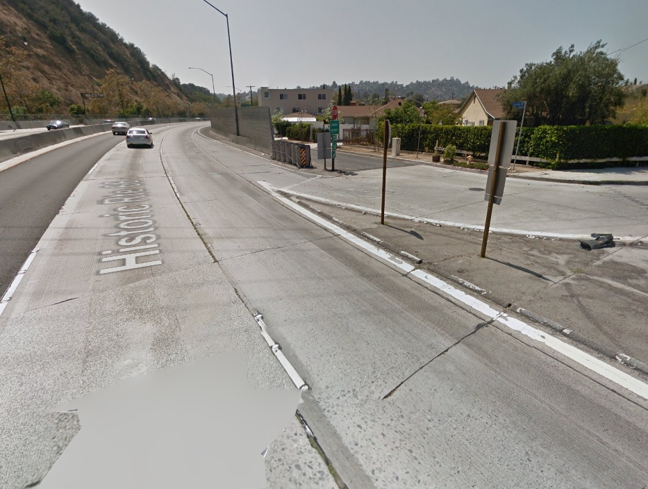 And yes, that is a stop sign right before the entrance. This can be a pretty painful highway to get onto in heavy traffic, but generally people try to avoid the outer lane if possible to give people a chance to get in. Unfortunately this road was designed and built in the 1930s snaking right in between houses and a river, so any modifications would be ridiculously expensive. Mountain Dew Code Bread fucked around with this message at 05:16 on Oct 13, 2015 |
|
#
?
Oct 13, 2015 05:12
|
|


|
Baronjutter posted:I don't think my city has any concrete roads, I've seen some concrete bus stops though. Actually there's a single concrete road in the entire region and it's a narrow rural road that tour buses use to get tourists to Buchart Gardens. There is a single collector road in my city that has a couple of concrete bus stops, but the bus routes no longer go down that road. It must have been put in as a trial or an experiment but the origins of it are seemingly lost in the mists of time.
|
|
#
?
Oct 13, 2015 06:39
|
|
|
Strangely up here in Fargo/Moorhead where we get nasty freeze/thaw cycles every year we have a lot of concrete roads. Most of the major roads in Fargo and virtually all new construction on both sides of the river is all concrete. https://www.google.com/maps/@46.877278,-96.7940316,3a,75y,166.7h,60.34t/data=!3m6!1e1!3m4!1sg80huxoPrJtRVU-S_OXjIw!2e0!7i13312!8i6656 https://www.google.com/maps/@46.871...!7i13312!8i6656 https://www.google.com/maps/@46.861...!7i13312!8i6656 https://www.google.com/maps/@46.853...!7i13312!8i6656 Some of these roads in the pictures are almost 10 years old and seem to be holding up very well.
|
|
#
?
Oct 13, 2015 22:39
|
|
|

|
| # ? Apr 19, 2024 10:46 |
|
|
Funny road related story I just remembered. I had a friend who lived on the curve of a road. Every time a bus or big truck went by their house would rattle like hell. They complained to the bus company, they complained to the city, no one took it seriously. Finally they got someone actually out to stand in the house while a big truck went by and they realized it was way louder than it should be. Finally the city figured it out. The road didn't used to curve, it went straight, and it was concrete. They had a single big slab of concrete going from under the road to partially under their house. The city actually send a crew out to dig a trench and jack hammer through the slab to isolate the house from the ancient road.
|
|
#
?
Oct 13, 2015 22:49
|
|