


|
Grape posted:Fixed that for you. I�d like to introduce you to the DUP
|
 #
?
Nov 2, 2022 00:33
#
?
Nov 2, 2022 00:33
|
|


|

|
| # ? Jul 3, 2024 04:23 |
|
|
Do not introduce anyone to the DUP. And especially not TUV. e: Jim Allister's thing, not Technischer �berwangversion or whatever. Guavanaut fucked around with this message at 00:57 on Nov 2, 2022 |
|
#
?
Nov 2, 2022 00:55
|
|


|
The best non-Northern Irish take on the Troubles will always be William Ulsterman: https://www.youtube.com/watch?v=wxpYW_w5pgo CONTEMPTUOUSLY, ANTA THE MUD! 
|
|
#
?
Nov 2, 2022 01:05
|
|

|
   A Buttery Pastry posted:I think coast is a stretch Yeah, check out how that coast stretches all the way from the top to the bottom of the country.
|
|
#
?
Nov 2, 2022 22:10
|
|

|
 
|
|
#
?
Nov 3, 2022 04:03
|
|

|
I dunno, swapping the two might be interesting if a tad too spicy.
|
|
#
?
Nov 3, 2022 05:33
|
|

|
swapping wouldn't be as meaningful as poland just plopping down on top of the texas triangle
|
|
#
?
Nov 3, 2022 05:39
|
|
|
The most fun Texas size comparison is it's almost exactly as big as 1914 Austria-Hungary And an almost similar shape
|
|
#
?
Nov 3, 2022 05:47
|
|

|
Psh. Alberta could fit an entire Finland within it's borders.  Is there a site or something that lets you "trim" countries. Like, if i wanted to determine the area of Canada without all the empty stuff based on cell coverage maps, how would i go about it? 
Powershift fucked around with this message at 06:07 on Nov 3, 2022 |
|
#
?
Nov 3, 2022 06:01
|
|


|
Good morning Mr. Edmonton
|
|
#
?
Nov 3, 2022 06:06
|
|
|
Powershift posted:Psh. Alberta could fit an entire Finland within it's borders. This seems to suggest far more people in Alberta than is truly accurate. I'm assuming it's coverage for the tar sands or something?
|
|
#
?
Nov 3, 2022 07:37
|
|


|

|
|
#
?
Nov 3, 2022 12:46
|
|
|

|
|
#
?
Nov 3, 2022 16:11
|
|

|
a pipe smoking dog posted:This seems to suggest far more people in Alberta than is truly accurate. I'm assuming it's coverage for the tar sands or something? 1) topography - interior BC (outside of Vancouver island and the lower Fraser) has close to the same population as Alberta outside of the two big cities (1.1M versus 1.3M). However, they're much more concentrated in the valleys than Alberta's rural population, which is spread out over the prairies... which are much easier to serve with cell towers than the bumpy bits of BC. 2) different companies - this is just the 5G map for Rogers, one of three national providers. Saskatchewan is mostly served by SaskTel which is kind of behind on installing their own 5G equipment; looks like Rogers just threw up towers to cover the two cities and the highways for roaming purposes. 3) different land use - there's a lot more people in Ontario and Quebec than Alberta, but they're much more concentrated. As anyone who's ever driven the trans-Canada highway can tell you, once you head east out of Winnipeg there's a whooooooole lot of nothing until you get south of Sudbury. (There's arguably a bunch of nothing on the Prairies, as well, but it's a different kind of nothing that might occasionally use a cell phone.) 
|
|
#
?
Nov 3, 2022 16:59
|
|

|
Am I remembering correctly that the Prairies area in Alberta one of the relatively few places on earth with the "Black Soil" thing going on that is particularly fertile?
|
|
#
?
Nov 3, 2022 17:22
|
|

|
AAAAA! Real Muenster posted:Am I remembering correctly that the Prairies area in Alberta one of the relatively few places on earth with the "Black Soil" thing going on that is particularly fertile?
|
|
#
?
Nov 3, 2022 17:38
|
|
|
Albino Squirrel posted:Chernozem, and yes. Though the soil is actually more chernozemic further east in Saskytoba. the prairies are pretty though. i wonder who brought these tables out
|
|
#
?
Nov 3, 2022 18:03
|
|
|
i say swears online posted:the prairies are pretty though. i wonder who brought these tables out Probably Parks Canada https://www.pc.gc.ca/en/voyage-travel/chaises-chairs
|
|
#
?
Nov 3, 2022 18:18
|
|

|
that rules
|
|
#
?
Nov 3, 2022 18:19
|
|
|
So is Ontario just a desolate wasteland tundra, besides the peninsula and the parts hugging the US border? That was the biggest surprise of the map for me. Why are there not even like farms in Ontario, beyond whatever the Toronto peninsula is called? It looks like there is basically nothing north of what appears to be called on google simply a maple leaf highway, with no number shown - just the symbol of a maple leaf. I see a few "towns" further north like Summer Beaver (lol) but when I zoom in there�s not even a single structure there.
|
|
#
?
Nov 3, 2022 19:37
|
|
|
ontario mostly misses the great plains so they don't see the summer highs of further west that get the prevailing southerly winds; i bet the great lakes take some heat out as well. this probably makes the growing season short and unpredictable, making anything north of thunder bay into logging territory, not suitable for clearance. that's conjecture tho
|
|
#
?
Nov 3, 2022 19:51
|
|
|
Saladman posted:So is Ontario just a desolate wasteland tundra, besides the peninsula and the parts hugging the US border? That was the biggest surprise of the map for me. Why are there not even like farms in Ontario, beyond whatever the Toronto peninsula is called? It looks like there is basically nothing north of what appears to be called on google simply a maple leaf highway, with no number shown - just the symbol of a maple leaf. That's the Canadian Shield - basically a thin layer of soil over just a TON of granite. It's pretty much useless for agriculture - if you get any settlements, they're based around mining. 
|
|
#
?
Nov 3, 2022 19:53
|
|

|
Saladman posted:So is Ontario just a desolate wasteland tundra, besides the peninsula and the parts hugging the US border? That was the biggest surprise of the map for me. Why are there not even like farms in Ontario, beyond whatever the Toronto peninsula is called? It looks like there is basically nothing north of what appears to be called on google simply a maple leaf highway, with no number shown - just the symbol of a maple leaf. That's the Canadian Shield for you. It's very very rocky, and also very very beautiful (in the summer). See all that red and orange stuff? It's basically rock all the way down, occasionally with some trees or water on top. 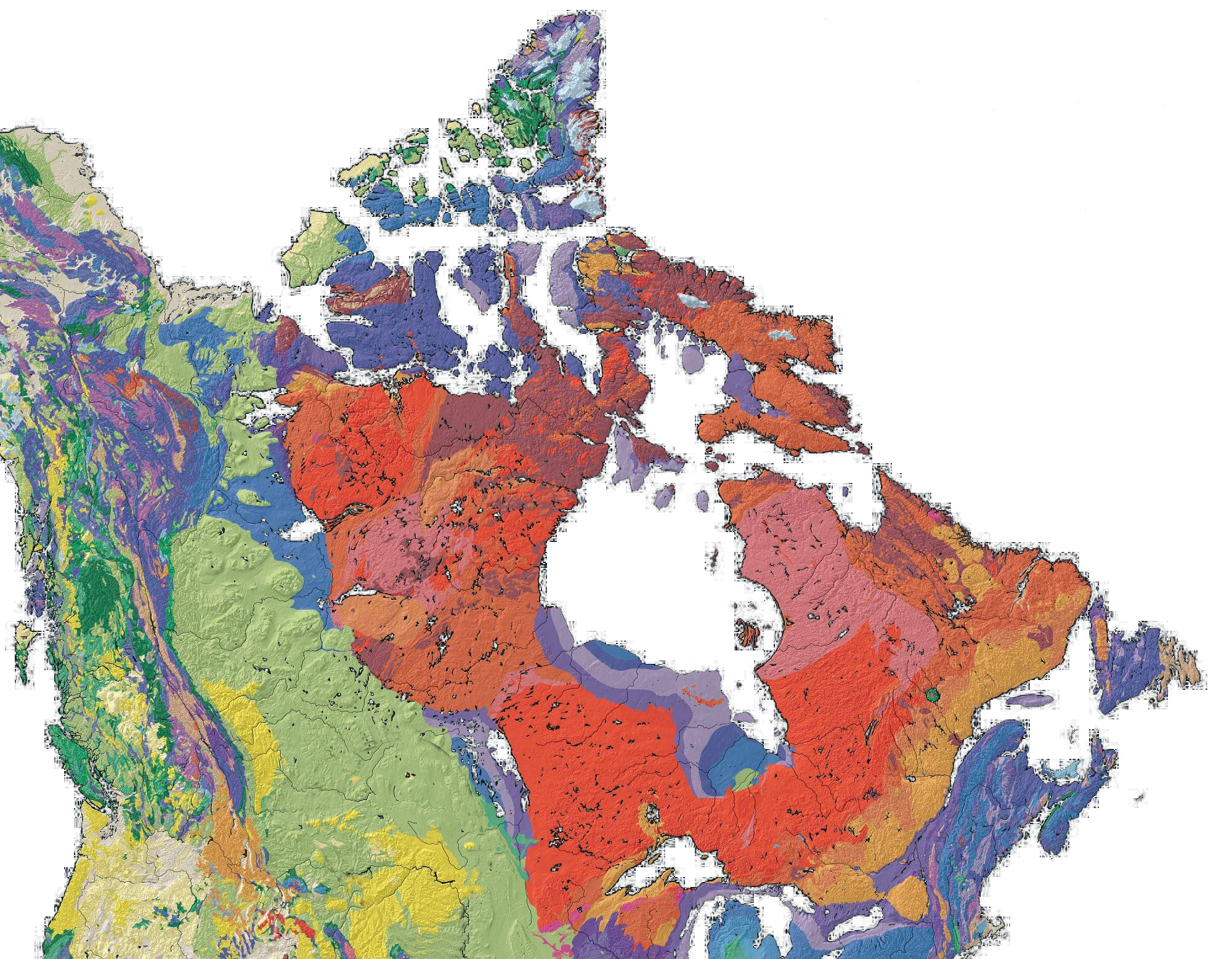  I haven't actually spent much time there but I drove across Northern Ontario this summer and it absolutely ruled. Top 3 drives in the country. e: f,b. PittTheElder fucked around with this message at 20:12 on Nov 3, 2022 |
|
#
?
Nov 3, 2022 20:04
|
|

 Yes, it's like a lava lamp.
|
Hey map geeks, kinda off topic but I want a nice globe in the house for my kid and I to look at, does anyone have any decent ones to recommend? They're hard to shop for in person and I've seen enough cheap crap globes with a lovely mount, a bad styrofoamy feel, and sometimes even bad maps, that I'm worried about ordering one online without some recommendations.
|
|
#
?
Nov 3, 2022 20:09
|
|


|
Freudian posted:That's the Canadian Shield - basically a thin layer of soil over just a TON of granite. It's pretty much useless for agriculture - if you get any settlements, they're based around mining. Neat, thanks both. Had never heard of that, but it sure is striking when I look at a map of how like the bottom half of Alberta and Saskatchewan are full of farms but much closer and more temperate parts of Ontario are just total wilderness.
|
|
#
?
Nov 3, 2022 20:36
|
|
|
I'm assuming the Canadian Shield thing has a pretty close analogue in Norway/Sweden/Finland, or is that a different kind of solid rock with no agricultural use?
|
|
#
?
Nov 3, 2022 20:41
|
|

|
Without knowing which parts of those countries to talk about, I couldn't say. As I understand it, in a past glacial period most of the soil got scraped off and dumped on the southern side of the shield when the glaciers melted, leaving Precambrian rock exposed. What little soil is there is from erosion since that glacial period, with minerals from the rock but little organic components. North of the Canadian Shield you get into permafrost. Things don't decompose quickly because of the cold, so the soil is loaded with organic acids and is poor in minerals. There are a lot of peat bogs up there, but it's as useless for farming as the Shield is.
|
|
#
?
Nov 3, 2022 20:52
|
|
|
Freudian posted:That's the Canadian Shield - basically a thin layer of soil over just a TON of granite. It's pretty much useless for agriculture - if you get any settlements, they're based around mining.  It's actually not all that cold or dry, at least in most of Ontario or Quebec - if it had more dirt it would be a reasonable agricultural area. As it stands the only thing the red zone supports is taiga (spruce forest) where it's warmer, and tundra up north. Thinking about it, I don't know why there's tons of dirt in the Prairies. I'm sure there's a reason why it all got dumped there instead of further south, and I know it's all glacial sediment because it's full of glacial erratic boulders and, in the case of my hometown, an ancient proglacial lakebed that makes it impossible to grow carrots 'cause it's too silty. Maybe because there's a bunch of land north of there that 'donated' its topsoil to the Prairies, whereas there wasn't as much to the north in eastern Canada? vv It very much is. vv Albino Squirrel fucked around with this message at 21:39 on Nov 3, 2022 |
|
#
?
Nov 3, 2022 21:05
|
|
|
even then it looks like agriculture stops in alberta only fifty miles north of edmonton, and everything past that looks like the same spruce taiga as ontario
|
|
#
?
Nov 3, 2022 21:22
|
|
|
There's a decent amount of farmland in the Peace region (Fort St John BC to Peace River (the town) AB) which is north west of Edmonton and sort of straddles the BC/Alberta border. There's also a few farmers further north along the Peace River around La Crete/High Level but they are mostly religious weirdos. Like more than the rest of the Prairies. There's even some small scale farming (mostly hay) coming out of the Yukon. But yeah, the Canadian Shield prevents any farming east of that.
|
|
#
?
Nov 3, 2022 22:55
|
|

|
i say swears online posted:even then it looks like agriculture stops in alberta only fifty miles north of edmonton, and everything past that looks like the same spruce taiga as ontario For the most part yes, it's mostly forest and muskeg (plus the tar sands NE of Edmonton) up there, but there is some high latitude farming going on way past Edmonton. It's not the same rocky Shield terrain though (except for the tiniest chunk of NE Alberta), it's Boreal Forest, and the soil is very crazy acidic.
|
|
#
?
Nov 3, 2022 23:25
|
|
|
Freudian posted:That's the Canadian Shield - basically a thin layer of soil over just a TON of granite. It's pretty much useless for agriculture - if you get any settlements, they're based around mining. And the soil that is there is sandy and acidic.
|
|
#
?
Nov 3, 2022 23:31
|
|
|
alnilam posted:Hey map geeks, kinda off topic but I want a nice globe in the house for my kid and I to look at,
|
|
#
?
Nov 4, 2022 01:56
|
|
|
Europe's seen better days, though I appreciate Scotland being physically separated from England, as is proper
|
|
#
?
Nov 4, 2022 02:24
|
|

|
i'm the single peg of farmland in morocco for all north africa
|
|
#
?
Nov 4, 2022 02:34
|
|
|
Albino Squirrel posted:Yeah, basically the entire topsoil got scraped off during the glacial periods and dumped further south. Long Island is built on stolen Canadian dirt The prairies have the soil for the same reason the Nile does - as first the glaciers and then Lake Agassi retreated, the whole area was a gigantic lake bottom and then river delta for thousands of years, with the sediment deposits that accompany that. If you've ever driven through extremely flat parts of the Red River valley (north and south of winnipeg) and been like "How the gently caress is this, literally the flattest thing I've ever seen, a "Valley,"" it's because it used to be a flood plain for one of the biggest rivers that ever existed, and the valley is so big and wide that you can be in the middle and not see either side.
|
|
#
?
Nov 4, 2022 04:39
|
|


|
The AutoTrain is the most  thing ever. It goes from the DC Metro area to just outside Disneyworld and lets people travel with their cars. thing ever. It goes from the DC Metro area to just outside Disneyworld and lets people travel with their cars.Picture of the 1973 AutoTrain, pre-Amtrak 
|
|
#
?
Nov 4, 2022 05:54
|
|
|
i have never heard of that lol
|
|
#
?
Nov 4, 2022 06:07
|
|
|
It's a great way to go to Orlando for a vacation with a car and would be more popular if not for the fact that flights from the Northeast Megalopolis to Orlando are consistently as cheap as flights get inside Europe. Like London to Dublin on Ryanair cheap. You can get a flight from Philly to Orlando for like $15 sometimes.
|
|
#
?
Nov 4, 2022 06:25
|
|
|

|
| # ? Jul 3, 2024 04:23 |
|
|
i paid $54 for a round-trip flight coming up in two months. i hate the drive and it's way cheaper than gas
|
|
#
?
Nov 4, 2022 06:28
|
|