


|
First of all, a big shoutout to Coolguye who lives up to his name by being helpful and providing good information about the game (and real life survival discussion)! I for one am glad the game doesn't require you to micromanage removing your shoes and changing your socks every hour! lofi posted:
The Dani are apparantly a real native people of New Guinea! The Wikipedia article doesn't mention anything about cannibalism though. The game's manual however, uh: The manual posted:As the last human remnants of the Stone Age, these unusual people are driven by tribal behavior ranging from friendly curiosity to sudden and cruel warfare. Battles can be waged over land disputes, over the need to placate the ghosts of their ancestors, or even over the theft of one pig. Their only weapons are spears and arrows; a Dani warrior can hurl a spear as far as 50 ft. The men remove all hair from their bodies (but not thier heads). They cover paint their faces with black soot mixed with pig fat in order to appear more handsome, as well as to ward off mosquitos. Their only clothing is a holim or tubular gourd worn over the genitals. Kepus, or unmarried men of marriagable age, remain unmarried until they can win the tribe�s respect by killing another man. Many kills and extreme courage are required for a man to attain the position of a kain, or overlord. ...apparently in the eighties they were some kind of New Guniean orcs...? But seeing as you can literally appease them with the command USE TRINKET, maybe it's safe to say that this game is not the most culturally sensitive in this regard? 
|
 #
?
May 22, 2018 20:56
#
?
May 22, 2018 20:56
|
|


|

|
| # ? Apr 24, 2024 06:42 |
|
|
It's October 4th, so we're pretty close to having 12 hours of daylight. Is the time given a convenience (i.e. zenith = 12 noon) or do we have to account for the latitude as well? Are there terrain features past the boundaries of the map? What would one see looking south from Pause-button Peak (the one just above the 'Level 5' at the bottom). As for what to do next, we should head roughly WNW until we hit a river. That'd confirm our position on the map and solve the water problem in one go. We don't need to cross it, of course, we can head upstream until we can ford it easily.
|
|
#
?
May 22, 2018 21:01
|
|

|
The latitude absolutely has to be taken into account - everything regarding navigation is simulated in very great detail. Makes sense too, since the sun is the main way to navigate in a game where you're not lucky enough to have a compass. The manual has some pretty in-depth stuff regarding navigating using the sun, including charts listing the azimuth of the sun setting and rising based on your latitude. As far as I know, the game generates terrain as far as you can see from the walk-able map area - although I haven't actually properly tried it out, as far as I know.
|
|
#
?
May 22, 2018 21:27
|
|
|
you can see it, but it's not modeled on the topo and if you try to go off the map noted by the topo the game will tell you to screw off and go back.
|
|
#
?
May 22, 2018 21:32
|
|

|
A mountain stream high in the catchment flowing straight downhill should be fairly safe to drink from, right? IIRC we have bread, have 1/4 of that for lunch. Kangra posted:As for what to do next, we should head roughly WNW until we hit a river. That'd confirm our position on the map and solve the water problem in one go. We don't need to cross it, of course, we can head upstream until we can ford it easily. I think if we walk NNW, we will hit the river higher up or at least pass very close to it. That helps us gain elevation without having to march straight up hill.
|
|
#
?
May 22, 2018 21:43
|
|


|
strictly speaking, any water that is clear and flowing quickly is pretty safe to drink. if you know where the headwaters are (or, better, you can drink from the headwaters) then that's even better. but any water that comes from the ground is potentially dangerous, full stop. even if you're drinking from a clear spring bubbling up from underground, it is possible that there is a microbial infestation in the surrounding soil that has been seeping in for a while. a more touchable example of this would be the hiking trails where they let people hike along streams to the headwaters, such as in the chickasaw recreational area in oklahoma. there's a gorgeous, crystal clear stream that is blissfully cold all year round that you can hike the length of, all the way to its headwaters. but really, do not drink from it, because obese assholes DRIVE to the headwaters and jam their nasty loving feet into the spring it's bubbling up from. unless you're down with drinking their foot gunk, at least. i'm unclear on how the game models this. my guess would be that it does what most games do and simply class different water sources at different levels of cleanliness. a pond is going to be much dirtier than a lake, which in turn will be dirtier than a river, which in turn will be dirtier than rain water (which is clean). the point is, Always Boil Your Water, if you have a choice. 2 minutes minimum, more at lower elevations. the ideal situation would be for goonpa to drink from his canteen until he's able to get to the riverside and make camp. once there, he can use the stove to boil water. remember that making camp, in and of itself, will require time and energy, so you will not want to wait until the dusk to start that process. do note that you need not necessarily drain your canteen prior to loading up on more water, either. you simply must consider it something less than 100% pure until you can boil the water and drain it back into your canteen. Coolguye fucked around with this message at 21:59 on May 22, 2018 |
|
#
?
May 22, 2018 21:55
|
|
|
 My best guess is that we're making 1mph across flat ground. lofi fucked around with this message at 22:58 on May 22, 2018 |
|
#
?
May 22, 2018 22:37
|
|


|
Bread and water for Goonpa! Then another 1.5h hike. I like Jaguars' NNW plan - best to try going uphill while we're fresh, I guess. Once we've crossed in-the-way-river and hook up with the dogleg river, all the slopes should be fairly gentle if we take a direct route.
|
|
#
?
May 22, 2018 22:56
|
|
|
Covski posted:What, and how much do we want to eat for lunch? Candy is lunch.
|
|
#
?
May 23, 2018 00:37
|
|

|
I only have one piece of wilderness advice to give. Don't eat yellow snow.
|
|
#
?
May 23, 2018 00:38
|
|

|
RBA Starblade posted:I suggest a standing rule to immediately consume anything we find, to keep Goonpas strength up rip aborigines
|
|
#
?
May 23, 2018 01:01
|
|

|
lofi posted:Bread and water for Goonpa! Then another 1.5h hike. I like Jaguars' NNW plan - best to try going uphill while we're fresh, I guess. Dong Quixote fucked around with this message at 03:37 on May 23, 2018 |
|
#
?
May 23, 2018 01:21
|
|


|
I'm not sure how much, but we should definitely drink. And I like the idea of eating some bread. Then NNW (315 magnetic?) for 1.5 hours. Also, lofi, thanks for the map updates. You're matching my feel for our position.
|
|
#
?
May 23, 2018 03:30
|
|

|
Yeah. That's actually about the course we've been walking on, when I first suggested it I fat fingered it and called it WNW. Maybe make it 320� because we seem to be naturally veering downhill from our course.
|
|
#
?
May 23, 2018 05:41
|
|
|
lofi posted:
Wow. That's... pretty terrible. But I suppose appropriate for a 350 pound goonlord. This LP is amazing and I'm loving it. I know a fair bit about survival from various sources and I've also walked the Vierdaagse in the military category so I'm very familiar with foot pain and walking yourself stupid. This should be fun. Coolguye posted:strictly speaking, any water that is clear and flowing quickly is pretty safe to drink. For game purposes, I absolutely agree. This is actually region-specific as my lovely home ranges of scandinavian mountains don't require you to boil your water unless it's a lemming year. In British Columbia, I feel like boiling water is mandatory. As far as wilderness survival is concerned, Canada is right up my alley, the closer to the arctic the better. A huge concern for Goonpa is probably going to be the weather, as rain will drastically reduce our temperature and ability to make a fire. The damp is a horrible enemy in near-freezing environments, it's actually more deadly at a couple degrees above freezing because snow doesn't make you wet the same way and is easier to shelter from. In fact, snow is a fantastic help in survival, and rain is pretty much all downside. A fun side effect of rain in arctic/tundra environs is that at higher altitudes (and depending on season), wetlands and lakes are less able to absorb heavy precipitation and areas such as Goonpa is in right now can actually experience the northernly equivalent of a flash flood. Lower areas sandwiched between mountains can become impassable during the course of a few hours and lovely creeks can become impossible to cross and useless for drinking water. This happened to me once in a mountainous area by a glacier, notorious for this exact thing. It was the weirdest experience seeing a lake suddenly double in size and I got trapped on the wrong side of a series of lakes and rivers and had to divert a good 10 miles back where I came from to find a crossing. Then it started snowing. In July. gently caress the mountains. Very surprised by that wolf. They are a lot more skittish than just that. Bears are a hell of a lot more dangerous, because they will absolutely actively seek out Goonpa to steal his food. I hope this game simulates suspending your food away from your campsite. For now, I agree with WNW direction trying not to climb in the terrain until we hit that river/creek and can see if we can get around it. Let's not expend energy that we don't need to. But first, drink from the canteen. Eat later.
|
|
#
?
May 23, 2018 13:43
|
|

|
Returning to the issues of gauging distances, have some pictures illustrating how this can be a very real thing: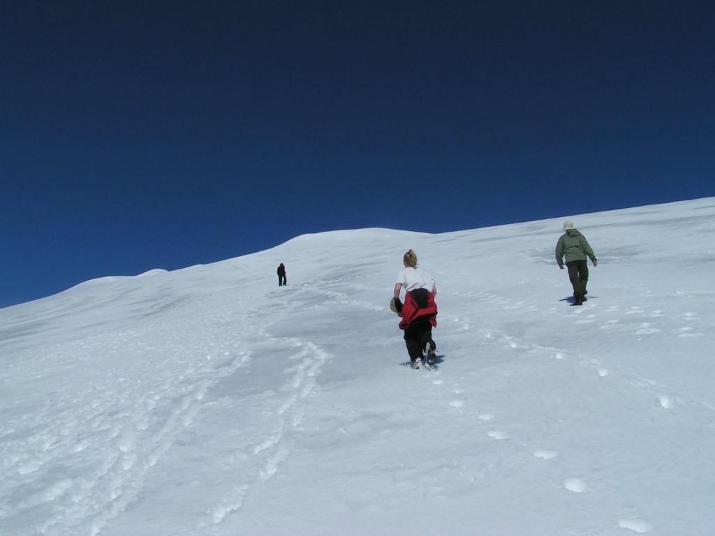 This is a photo from many years back from a stroll up Glittertind, the second highest mountain in Norway (2465 meters above sea level, including the glacier on top). You might be forgiven for thinking you're getting near to the summit at this point, right? You'd be wrong. 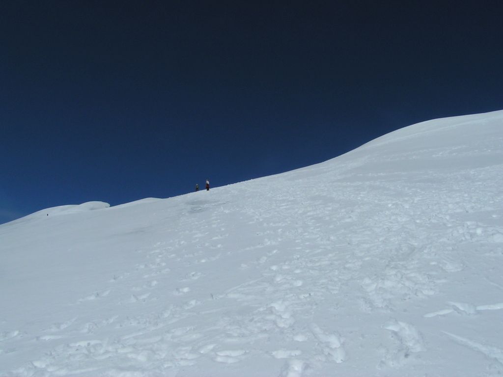 This photo was taken after another fifteen minutes of walking. Suddenly the summit doesn't seem as close any more, does it? Then you notice the little black speck near the left of the image and realise that that's your buddy in dark clothes from the first image: This is the point when you start getting demoralised by the prospect of walking up an eternal slope in ankle-deep snow. 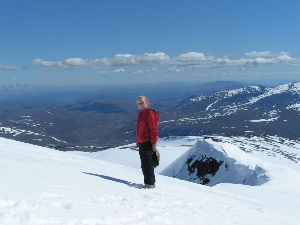 The view was well worth it though! In the game, of course, this issue is a bit exaggerated, especially with regards to terrain features reasonably close to you. (it's generally a safe bet to assume that objects are farther away than they appear) This is partially a concession to the graphics of the time, and partially an intentional way of teaching the importance of orienting yourself by looking at landmarks in relation to other objects and yourself, rather than assuming that you can estimate your location simply by the distance to the closest landmark. Checking the manual a little closer, I found this little footnote hidden away: quote:The contour lines on your topo map appear in increments of 400 feet. (To increase your journey�s challenge, the number of degrees of all slopes have been increased four times what is actually indicated on the topo map) I'm not entirely sure how to interpret this, will have to investigate further.
|
|
#
?
May 23, 2018 14:23
|
|
|
quote:(To increase your journey�s challenge, the number of degrees of all slopes have been increased four times what is actually indicated on the topo map) Thanks for that; I was confused as to why there'd be an angle indication when the terrain is so flat. Yeah, it turns out we're just 18 inches tall. I'd still argue for heading about 300 magnetic (I realized we need to be clear about stating the bearing system) since turning far northerly adds a fair amount of distance to our trip toward the river. On the other hand we may be moving pretty quickly, so it's hard to say. If we go a few hours at a time then later adjustments are okay. For lunch, we're not cooking anything. Drink from the canteen and eat some bologna and bread.
|
|
#
?
May 23, 2018 17:22
|
|
|
Covski posted:Returning to the issues of gauging distances, have some pictures illustrating how this can be a very real thing: I think I know that chick.
|
|
#
?
May 23, 2018 17:44
|
|
|
Kangra posted:I'd still argue for heading about 300 magnetic (I realized we need to be clear about stating the bearing system) since turning far northerly adds a fair amount of distance to our trip toward the river. On the other hand we may be moving pretty quickly, so it's hard to say. If we go a few hours at a time then later adjustments are okay. I think the idea is to try and get further upstream on the river we need to cross, before meeting the river that goes around Steep Mountain. I'm torn on this, as you point out it'll increase the distance we walk (and worse, it's uphill), but I'm really dreading that river crossing. Also, lofi described the rivers as in-the-way-river and the dogleg river. I say we make those our official names: In-The-Way-River and Dogleg River.
|
|
#
?
May 23, 2018 18:02
|
|
|
Which of the peaks is Mt. Whatever?
|
|
#
?
May 23, 2018 18:18
|
|


|
quote:Very surprised by that wolf. They are a lot more skittish than just that. beyond that, you can sometimes encounter a pack, and those are much more aggressive and dangerous. quote:Bears are a hell of a lot more dangerous, because they will absolutely actively seek out Goonpa to steal his food. I hope this game simulates suspending your food away from your campsite. ")
Coolguye fucked around with this message at 18:35 on May 23, 2018 |
|
#
?
May 23, 2018 18:32
|
|
|
Coolguye posted:there is a SCARE command that takes advantage of exactly this. one of the things playing games primes you to be prepared for that doesn't translate over to this game specifically. individual wolves like the one we ran into in the theoretical timeline are very likely to just leave you alone, not even doing anything if your command is just WALK 1.5 HRS and you imply that you ignore the wolf completely. even though these are 100lb timber wolves, singular specimens are very likely to just gently caress off without bothering goonpa unless he does something stupid, like attempt to kill it with a knife or a club. part of the deal with running into potentially dangerous wildlife in this game is giving you the ability to do something stupid. This game is loving awesome.
|
|
#
?
May 23, 2018 18:42
|
|
|
To get to our destination, we're going to have to climb at least 500m anyway. OTOH, I guess we need to be thinking about our night spot as well, since by the time we cross the river we'll probably only have a couple of hours before dark. Do we want to descend to the trees near steep mountain?
|
|
#
?
May 23, 2018 21:24
|
|
|
Hey guys, probably no proper update tonight so feel free to keep discussing our immediate plans, and also if we want to institute a "eat every kind of potentially edible thing we find on the ground" rule. Also, remember that we're still carrying around that raft, when considering how to deal with that river! Nice piece of fish posted:I think I know that chick. Assuming you're not just being a creepy goon, feel free to pm me to see if we have a mutual acquaintance! (no doxxing in this thread!!)Edit: Remember that you're very welcome to request a view of any particular direction (this includes looking up or down), as well as an update on our status or inventory at any time. Covski fucked around with this message at 21:36 on May 23, 2018 |
|
#
?
May 23, 2018 21:33
|
|
|
Covski posted:
Yup, I'm pretty sure that's Ingebjerg Totenlefse, nine times national champion lutefisk-thrower from Sykkylven. I'd recognize that throwing arm anywhere.
|
|
#
?
May 23, 2018 21:40
|
|
|
I said no doxxing 
|
|
#
?
May 23, 2018 21:41
|
|
|
Covski posted:I said no doxxing My bad. I'm actually interested in the story of why you were climbing Glittertind though, it's a lovely trip for sure. Do you have a lot of mountaineering experience? Why the hell climb in the most expensive mountainous country in the world? Why Glittertind and not Galdh�piggen?
|
|
#
?
May 23, 2018 21:45
|
|
|
Covski posted:if we want to institute a "eat every kind of potentially edible thing we find on the ground" rule. No that is silly. If we've got room, we should grab it, though, for later sorting / cooking the gently caress out of / in case we get desperate. I think we should hold off on the river crossing for tonight even if we find a really good spot - it'll likely have complications, and leave us soaked, so lets not do that right before nightfall. Nothing like an early morning icebath to get Goonpa in the mood for adventure!
|
|
#
?
May 23, 2018 22:01
|
|
|
Can you bribe aggressive animals with food?
|
|
#
?
May 23, 2018 22:04
|
|


|
there is the TASTE command. TASTE-ing most wild plant life will give you a pretty good idea of how good it is to eat. human tongues are a lot more sensitive than people give them credit for, and we can discern most poisons as bitter. this is less true in the case of mushrooms, but leafy plants and fruits follow this rule pretty well.
|
|
#
?
May 23, 2018 22:10
|
|
|
Nice piece of fish posted:My bad. I'm actually interested in the story of why you were climbing Glittertind though, it's a lovely trip for sure. Do you have a lot of mountaineering experience? Why the hell climb in the most expensive mountainous country in the world? Why Glittertind and not Galdh�piggen? Well, the idea was going for a mountain hike with a gang of friends from my time in the scouts, and coming from central Sweden, Norwegian mountain ranges are a lot closer than northern Swedish ones. Being able to buy all our supplies beforehand meant that we didn't suffer too much from the absurd expensiveness, aside from paying something like 50 NOK for a box of Pringles at a mountain station. It was very worth it though. We were all decently experienced hikers, if not used to any real mountaineering. That said, even Glittertind was never challenging in any technical sense, never being steeper than what you can see in those pictures. We we're quite badly prepared for the journey in many ways (including regarding how badly the sun burns you at that middle of summer at altitude), and the trip was a great collection of misadventures including rock slides and people sliding down snowy ravines. Incredibly, we all came home relatively unscathed! As for why we decided for Glittertind over Galdh�piggen, I couldn't say - I wasn't very involved in the planning process. The general plan was a ten day hike through the Jotunheimen area, and I guess Glittertind just fit better into the general route. v:)v Glittertind was just a one day excursion while we camped by the Spiterstulen lodge, before moving on. Have some more pictures! 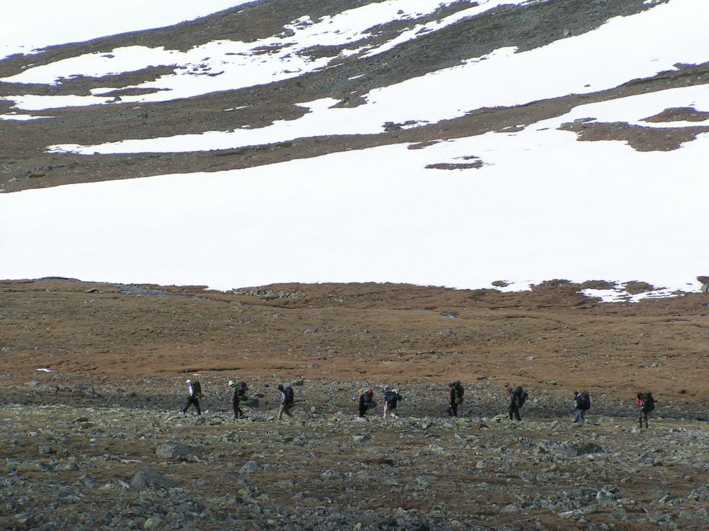 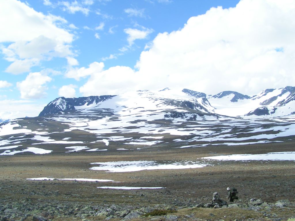 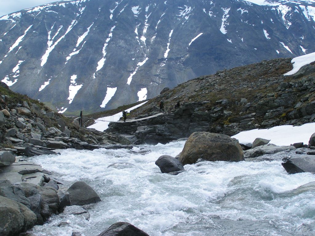 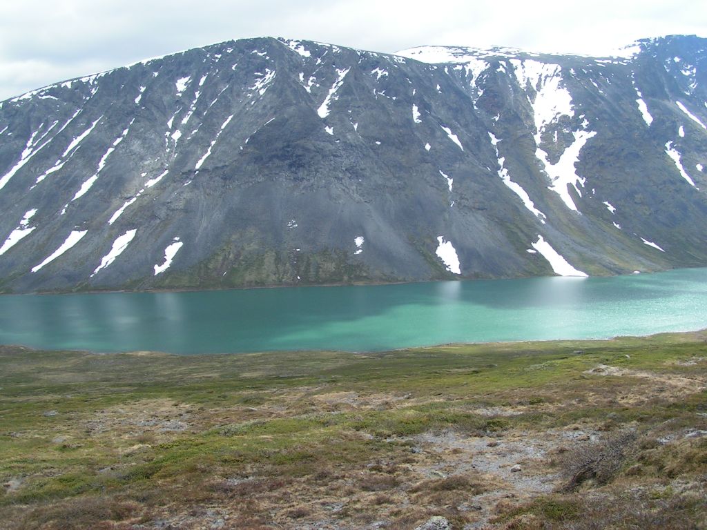 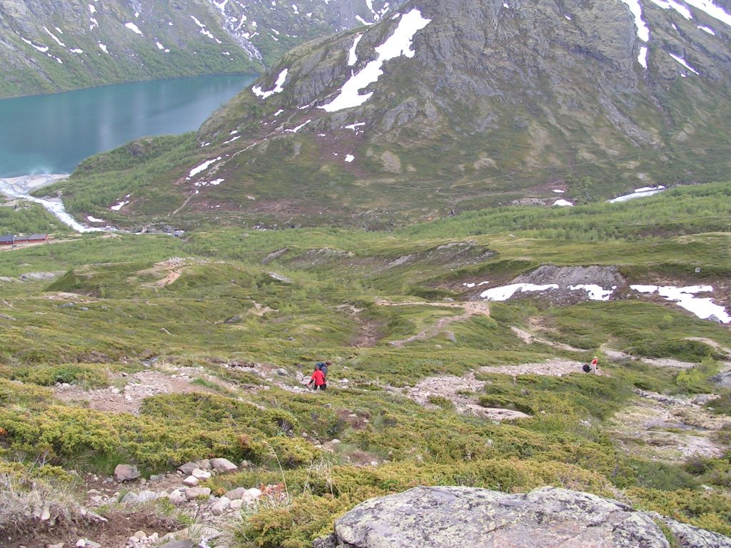
|
|
#
?
May 23, 2018 22:20
|
|
|
Covski posted:Well, the idea was going for a mountain hike with a gang of friends from my time in the scouts, and coming from central Sweden, Norwegian mountain ranges are a lot closer than northern Swedish ones. Being able to buy all our supplies beforehand meant that we didn't suffer too much from the absurd expensiveness, aside from paying something like 50 NOK for a box of Pringles at a mountain station. It was very worth it though. Those are some nice pictures. Thanks a lot, my curiosity is satisfied. To be fair, Galdh�piggen is underwhelming and crowded by norwegian standards. In my opinion you made the right choice. Also give back Jamtland and Herjedalen.
|
|
#
?
May 24, 2018 08:45
|
|
|
Covski posted:Well, the idea was going for a mountain hike with a gang of friends from my time in the scouts, and coming from central Sweden, Norwegian mountain ranges are a lot closer than northern Swedish ones. Being able to buy all our supplies beforehand meant that we didn't suffer too much from the absurd expensiveness, aside from paying something like 50 NOK for a box of Pringles at a mountain station. It was very worth it though. I assume you're able to understand spoken Norwegian fairly well, so... I'd recommend checking out this TV show that just ended, which follows Norwegian comedian Truls Svendsen in his attempt at climbing motherfucking Aconcagua. It's really entertaining and gives a decent amount of info on how to actually climb of such extreme heights: https://www.youtube.com/watch?v=-zXDQjGiwYg (not sure if the video is region protected, it might be)
|
|
#
?
May 24, 2018 12:29
|
|
|
Coolguye posted:there is the TASTE command. Well then, let's be tasting everything we see on this walk. Obviously if it's bitter we'll spit it back out, but everything else should be fair game.
|
|
#
?
May 24, 2018 14:46
|
|
|
e: Apparently nature actively wants us dead. gently caress nature. Let's pick up ground-food we find, and keep it for a last resort - it'll keep for a while in these temperatures. lofi fucked around with this message at 00:29 on May 25, 2018 |
|
#
?
May 24, 2018 19:33
|
|
|
reread the manual and note that milky sap is the other warning sign for plants. glad i did, i only knew the bitter portion off the top of my head and just happened to remember the TASTE command.
|
|
#
?
May 24, 2018 19:34
|
|
|
idhrendur posted:Well then, let's be tasting everything we see on this walk. Obviously if it's bitter we'll spit it back out, but everything else should be fair game. How about this? Should we TASTE this one?  It would probably taste okay, or at least edible. Won't taste bad. Actually tastes delicious. Maybe we'd decide to grab some berries or eat a handful to keep up our strength. It's atropa belladonna. https://en.wikipedia.org/wiki/Atropa_belladonna Deadly Nightshade. It grows wild in north america (though I kinda doubt it grows in the area we're supposed to be in), and it's one of the most poisonous plants we could possibly ingest. A death sentence. I vote to never eat anything we pick up off the ground and stick with our carried food which ought to last us to where we want to go. At least, no plants or berries, and definitely no mushrooms. Maybe a fish if we can catch one, or a grouse.
|
|
#
?
May 24, 2018 20:02
|
|
|
Nice piece of fish posted:. It grows wild in north america (though I kinda doubt it grows in the area we're supposed to be in), I'm actually wrong, it's widespread along most of the pacific northwest. Shows what I know.
|
|
#
?
May 24, 2018 20:06
|
|
|
you got me thinking about that so i crunched some numbers real fast. in terms of calories we are carrying currently, per what is in our pack in this image: (16*141)+(48*110)+(80*100)+(48*160)+(16*125)+(16*100)+(32*93)+(32*70) = 32,032. the game expects you to eat at least 2k calories a day to ward off starvation (which is an insanely low number considering the physical activity), so ostensibly we have about 2 weeks of food, failing any spoilage. also, almost all of our food is freeze dried or does not spoil naturally, so fish is correct that we actually have a shitton of food basically all of it isn't going anywhere. the only exceptions are the potatoes (80 oz, 100 calories an ounce) which spoil in 10 days, and the bread (32 oz, 70 calories an ounce) which will spoil in 3 days. that's at 65F, though, which is warmer than we currently are. if we brought the bologna, that will spoil fastest at 24 hours, but i did not include it because it appears to be on the ground in the linked picture.
|
|
#
?
May 24, 2018 20:16
|
|
|

|
| # ? Apr 24, 2024 06:42 |
|
|
Coolguye posted:you got me thinking about that so i crunched some numbers real fast. in terms of calories we are carrying currently, per what is in our pack in this image: Agreed, particularly the bolded part. This kind of activity I'd place north of 3k calories per day to avoid energy/heat issues (cold weather makes you burn more food to keep warm) and for a 350 pound goon I'd place it at least a thousand higher. Not that it would matter if we're being real, a 350 pound dude would have serious issues whatever the calories available.
|
|
#
?
May 24, 2018 20:26
|
|