


|
TinTower posted:I'm surprised Welsh is so high for Britain; I would've thought it would be Polish or Urdu. The figure for Welsh is the number of people who claim to be able to speak Welsh, not the number of people with Welsh as a first language; it's possible to learn Welsh as a second language (and it's compulsory to learn in publicly-funded school in Wales), but it's somewhat harder to lose the ability to speak what was your first language, so the true figure for first-language-Welsh-speakers must be lower than 562,000. Only 431,000 of these people claim to be able to speak, read and write Welsh, which again, is likely to be more than the number for whom it's their first language. Given that there are 300,000-400,000 French people living in the UK (almost all of them French-first-language) and that French is not listed in your table, I would not trust the census to determine the true figures for this discussion. http://www.bbc.co.uk/news/magazine-18234930
|
 #
?
Dec 15, 2013 23:03
#
?
Dec 15, 2013 23:03
|
|


|

|
| # ? May 2, 2024 10:36 |
|
|
3peat posted:As a Balkans resident, and thus an expert on the subject, I can tell you the answer is: more clay=better U r dirt romain gypsy, not balkan,  (Where the gently caress did clay come from again? Is it just a Paradox forums thing?)
|
|
#
?
Dec 16, 2013 00:02
|
|

|
I think it is from that Serbian Tupac video. And Romanians aren't from Balkans, stay out of our clay. 
|
|
#
?
Dec 16, 2013 00:51
|
|


|
Man Russia has a gently caress-ton of permafrost, jesus. Speaking about the border of Russia and China, I find it neat how virtually their entire shared border follows the path of a river/series of rivers. Makes a handy border, and was something I found just by closely looking at maps once. And while I was looking at said rivers, I noticed that there was a Russian province called the "Jewish Autonomous Oblast", which borders China. Here is an amusing image which shows the location as well as the coat of arms and (rainbow) flag of the province: 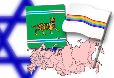 Turns out there is an interesting Jewish history in Manchuria as well, though I haven't looked into the details there.
|
|
#
?
Dec 16, 2013 03:41
|
|

|
I guess Stalin wanted to create a territory for Soviet Jews so that less of them would want to run off to Palestine. Apparently, it's less than 1% Jewish nowadays, so it wasn't a shining success.
|
|
#
?
Dec 16, 2013 04:25
|
|

|
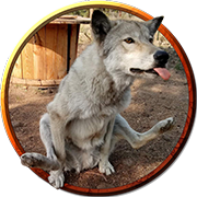
Lycus posted:I guess Stalin wanted to create a territory for Soviet Jews so that less of them would want to run off to Palestine. Apparently, it's less than 1% Jewish nowadays, so it wasn't a shining success. Mainly because the location of the Jewish oblast is literally this: A Buttery Pastry posted:I'm not sure an ecosystem consisting entirely of mosquitoes is gonna make up for those.
|
|
#
?
Dec 16, 2013 04:35
|
|

|
DrSunshine posted:Siberia does have vast quantities of natural resources, but I've heard that it's tremendously, prohibitively expensive to develop and extract there because of the harsh climate and landscape. So much so that the opportunity cost for not developing Siberia is relatively low compared to the cost of prospecting it. I'm no expert on Russian economic development or geography, though, so can anyone confirm/refute that? Other posters already conveyed the gist of it, but the problem is that seasonal expansion and contraction of the soil over permafrost destroys permanent structures, including roads. Unpaved roads turn into rivers of mud, and paved roads last maybe 2 years before they're unusable even by the most rugged road vehicles. You can find pictures of Siberian highway that's heaved into big piles of asphalt rubble. That's why Siberia is so hard to exploit.
|
|
#
?
Dec 16, 2013 04:41
|
|

|
Disco Infiva posted:I think it is from that Serbian Tupac video. ACTUALLY, I live in Dobrogea, the only part of Romania that's officially part of the Balkans (it's on the other side of the Danube, which is the Balkan area border)
|
|
#
?
Dec 16, 2013 07:12
|
|

|
 Map of countries by cannabis use by percentage of the population. Guessing there's ritual significance for the high rates in Papua New Guinea and Ghana? Found it somewhat amusing at least :P
|
|
#
?
Dec 16, 2013 20:14
|
|

|
Whorelord posted:
The percentages in the Caribbean seem awfully low...
|
|
#
?
Dec 16, 2013 21:24
|
|

|
New Guinea  Time Magazine posted:It is also hard to stop people smoking. As a social phenomenon, marijuana is relatively new to P.N.G., yet it has taken a firm hold. "It's only been like this in the past four or five years: marijuana came first, then the home brew," says police Supt. Leo Kabilo, who is based at Wewak, on the country's north coast. A U.N.-sponsored study in 1999 found that cannabis was the "illicit drug of greatest concern" in P.N.G. Whether on the streets of the capital, Port Moresby, or in a rural town, spak brus, "tobacco that makes you drunk," is not difficult to find. A "roll," a homemade cigarette weighing less than a gram, costs 6� in a village, 15� in a town, and up to 60� in Port Moresby. Read more: Savage Harvest In Papua New Guinea, marijuana brings in not just cash but guns. From highlands to coast, time penetrates the world of growers, warriors, police and traffickers - TIME http://content.time.com/time/world/article/0,8599,2047527,00.html#ixzz2nftrqVjA
|
|
#
?
Dec 16, 2013 22:17
|
|

|
Whorelord posted:Guessing there's ritual significance for the high rates in Papua New Guinea and Ghana? Orientalism, ladies and gentlemen.
|
|
#
?
Dec 16, 2013 22:21
|
|

|
 Literally me, not gonna lie. EDIT: Admittedly it was a really dumb thing to say. Not going to edit it out though, so future generations can revel in my idiotness. Whorelord fucked around with this message at 00:27 on Dec 17, 2013 |
|
#
?
Dec 17, 2013 00:07
|
|
|
Someone posted this in one of the Paradox LPs http://www.jasondavies.com/maps/transition/ It shows different types of world map projections and lets you move stuff around. I'm having fun trying to make the least practical maps possible.
|
|
#
?
Dec 17, 2013 06:18
|
|

|
What good is projecting to Goode Homolosine if it won't add the splits in the right places 
|
|
#
?
Dec 17, 2013 08:44
|
|

|
Mu Cow posted:Someone posted this in one of the Paradox LPs http://www.jasondavies.com/maps/transition/ No Waterman butterfly projection  Content: Potential nuclear targets in the United States (Source: Natural Resources Defense Council, FEMA and Medicine and Global Survival(?)  The key is small, so: Black dot: Target in a 2000 warhead scenario Purple triangle: Target in a 600 warhead scenario Red asterisk: State capital Red square: City As someone who's not American, can someone clarify what the 2000-warhead targets in North Dakota, Montana and around Cheyenne are? US missile silos? And then I suppose the other black dots are generally just major cities, military placements and the like? The Narrator fucked around with this message at 09:26 on Dec 17, 2013 |
|
#
?
Dec 17, 2013 09:19
|
|

|
The Narrator posted:As someone who's not American, can someone clarify what the 2000-warhead targets in North Dakota, Montana and around Cheyenne are? US missile silos? And then I suppose the other black dots are generally just major cities, military placements and the like? Yeah, missile silos. And the three dots just south of Denver is Cheyenne Mountain, with NORAD HQ. I like the very clear division between the 2000 warhead first strike scenario, and the 600 warhead gently caress You retaliatory strike. PittTheElder fucked around with this message at 09:38 on Dec 17, 2013 |
|
#
?
Dec 17, 2013 09:35
|
|

 Yes, it's like a lava lamp.
|
Only three at NORAD HQ? It would survive three hits.
|
|
#
?
Dec 17, 2013 09:40
|
|

|
It would probably survive 50 hits, and by the time the warheads hit it it would already have done it's job. The three that are there are probably more intended for the personnel at the adjacent military base really.
|
|
#
?
Dec 17, 2013 09:45
|
|
|
What's the spot on the Canadian border with Idaho?
|
|
#
?
Dec 17, 2013 12:03
|
|

|
The Narrator posted:No Waterman butterfly projection Would there be one that includes the rest of the US and Canada?
|
|
#
?
Dec 17, 2013 12:15
|
|

|
Lawman 0 posted:Would there be one that includes the rest of the US and Canada? Google isn't being helpful with the keywords I'm trying and the page I found it on doesn't appear to have anything similar, sorry I can't be more help! As a consolation, here's a link to some page where nuclear-war survivalists across the US and Canada can organise their apocalypse plans!
|
|
#
?
Dec 17, 2013 12:28
|
|
|
Nobody gives enough of a crap about you to nuke you too much, Idaho.
|
|
#
?
Dec 17, 2013 12:52
|
|
|
I'm trying to figure out what the triangle in southern Oregon is. They ignore Eugene but hit Medford?
|
|
#
?
Dec 17, 2013 14:42
|
|


|
Javid posted:I'm trying to figure out what the triangle in southern Oregon is. They ignore Eugene but hit Medford? Google says there's a National Guard, Medford Armory and a US Navy Reserve center in the area. Not sure why it's part of a 600-missile strike but there you go.
|
|
#
?
Dec 17, 2013 14:54
|
|
|
Numerical Anxiety posted:What's the spot on the Canadian border with Idaho? There's a lake there where they test nuclear submarines iirc. Actually, the one I'm thinking of is here but there is a lake there so maybe they do some of that over there as well.
|
|
#
?
Dec 17, 2013 15:07
|
|

|
Why aren't there a million nukes in Nevada? We don't want to anger the aliens, isn't it 
|
|
#
?
Dec 17, 2013 15:17
|
|
|
Lycus posted:Nobody gives enough of a crap about you to nuke you too much, Idaho. If I'm reading that map right, everyone in Idaho basically lives in one place anyway? Soviets really hated Montana though.
|
|
#
?
Dec 17, 2013 15:21
|
|

|
Ahh, good to see my hometown targeted for a strike. Bumfuck nothing, except for a large titanium/rare metals refinery.
|
|
#
?
Dec 17, 2013 15:32
|
|

|
DarkCrawler posted:If I'm reading that map right, everyone in Idaho basically lives in one place anyway? Half of the state (~620k) lives in the Boise Metropolitan area, which is where the triangle is. The one black dot that's on the Here's a map circa 2010:  As you can see, the only areas they're really missing are Idaho Falls (the red splotch farthest east) and Pocatello (the red splotch below Idaho Falls), which have a combined population of ~100,000 (metro area's about 240k but you get the idea). computer parts fucked around with this message at 15:40 on Dec 17, 2013 |
|
#
?
Dec 17, 2013 15:34
|
|
|
DarkCrawler posted:Americans-pretending-to-be-Soviets really hated Montana though.
|
|
#
?
Dec 17, 2013 15:37
|
|


|
DarkCrawler posted:If I'm reading that map right, everyone in Idaho basically lives in one place anyway? The small towns in Idaho where the people who don't live in the one place live are truly something miserable.
|
|
#
?
Dec 17, 2013 15:49
|
|


|
DarkCrawler posted:Soviets really hated Montana though. 
|
|
#
?
Dec 17, 2013 15:58
|
|
|
DerLeo posted:The small towns in Idaho where the people who don't live in the one place live are truly something miserable. Some of them have a sense of humor though:  Yes, that is a monument solely dedicated to a sub whose number was 666.
|
|
#
?
Dec 17, 2013 16:05
|
|
|
 Best and worst drivers by state. The lighter colored the state, the better the drivers. Vermont has the best, Louisiana has the worst. http://www.dailymail.co.uk/news/article-2524438/Hell-wheels-The-state-Americas-worst-drivers-revealed.html It's interesting, because living in the northeast (VT  ), I hear most often is that MA drivers (Massholes) and NJ drivers are the worst, yet that's not even remotely true. ), I hear most often is that MA drivers (Massholes) and NJ drivers are the worst, yet that's not even remotely true.I suspect that the instances of DUI's are what drive lot of states up.
|
|
#
?
Dec 17, 2013 16:16
|
|


|
A Buttery Pastry posted:I don't think either side has ever given out their targeting plans, so they're all based on how the target portrayed on the map would act.  I'm not sure if they are the same source but it's one of the only maps I've seen that shows where the USSR believed NATO would nuke.
|
|
#
?
Dec 17, 2013 16:34
|
|

|
Mu Cow posted:Someone posted this in one of the Paradox LPs http://www.jasondavies.com/maps/transition/ It freaks out if you go from Mercator to Miller while paused
|
|
#
?
Dec 17, 2013 16:44
|
|
|
Swan Curry posted:Sorry to drag this up from the last page,but I just wanted to show something.See that small part of the west of Ireland?That's the area that was hit the hardest by the Great Famine.Between 1 million deaths and the emigration of around 1 million more,the country's population dropped by a quarter in around five years.The majority of the people who died were Irish speakers,part of why Irish is dying nowadays. In addition to that, the population of Ireland continued to drop due to emigration for over a century after: there are still two million fewer people living in Ireland than there were in 1841, and the countryside is still dotted with the stone walls of little old houses uninhabited since the 1840s. Though one clarification I do need to make is that the relatively uninhabited areas of western Ireland aren't that way because of this so much because of lingering effects of the famine, as they are because they're largely uninhabitable stretches of patchy grass and moss spread out over nearly bare rock. You can raise some sheep, but the only reason any numbers of people tried to live or farm there in the 1840s was overpopulation, desperate poverty, and people driven west since that part of the country was last to fall firmly under British control. It's even more fun out on some of the islands, where what soil there is was literally created by settlers hauling sand and seaweed up from the beach to spread onto the rock. Similarly, I gather there's a lot of marginal land in Scandinavia or other northern areas that hasn't been farmed since the Black Death: it was only farmed because land demand was so high, and the literal centuries the population took to recover coupled with climate change and improved farming methods meant no one ever wanted it again.
|
|
#
?
Dec 17, 2013 16:53
|
|

|
DrBouvenstein posted:
The correct answer is DC. DC has the worst drivers. Since moving here, I've seen poo poo that'll turn you white. 
|
|
#
?
Dec 17, 2013 16:59
|
|

|

|
| # ? May 2, 2024 10:36 |
|
|
DerLeo posted:The small towns in Idaho where the people who don't live in the one place live are truly something miserable. So basically nuke them, don't nuke them...people wouldn't find a difference anyway, so might as well spend the nukes on someone not living in third world conditions?
|
|
#
?
Dec 17, 2013 17:17
|
|