|
When i would start a new fantasy series the first thing I'd do is pour of the maps to get a sense of the world. Where are our heroes starting in relative to everyone else? Who are the boarding nations, which one are enemies and which are allies? Fantasy loves to toss out location names casually and knowing the map helps avoid being confused. But you still want to flip back to the front to see where the Kingdom of Fartis. Sci-fi has great maps too, you can look over a entire galaxy and see the breath of the setting. They're maps so they go from functional  To trying to replicate some sort of google maps style  Still some hold mysteries  And some are just earth but weird  And some are only a possible of many  I don't think there is one official map of the star trek galaxy, but this one tends to be the one that's considered "most" canon. It probably doesn't help is there are a zillion planets added to it constantly.
|
 #
?
Jun 2, 2022 04:50
#
?
Jun 2, 2022 04:50
|
|


|

|
| # ? Apr 26, 2024 10:21 |
|
|
 "We shall conquer the entire Inner Sphere!...... Actually, this is fine." "We shall conquer the entire Inner Sphere!...... Actually, this is fine."  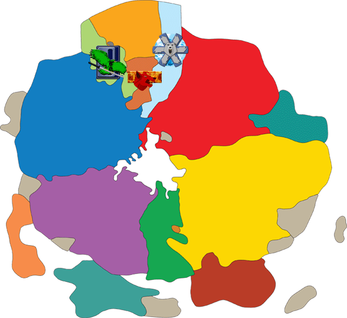
|
|
#
?
Jun 2, 2022 20:43
|
|
|
Animal-Mother posted:
We're all kickass fighters, we don't need things like logistics and supply dumps! Inner sphere has outdated tech and they are always infighting!
|
|
#
?
Jun 3, 2022 22:07
|
|
|
I don't have much to add other then as someone who enjoys looking at and studying maps of real places, I also enjoy and will pour over maps of fictitious places as well if it's a setting I enjoy. I just really like maps I guess, they spark my imagination.
|
|
#
?
Jun 4, 2022 13:31
|
|


|
Twenty Four posted:I don't have much to add other then as someone who enjoys looking at and studying maps of real places, I also enjoy and will pour over maps of fictitious places as well if it's a setting I enjoy. I just really like maps I guess, they spark my imagination. That's why i started the thread. I love looking at maps of real places, and many fantasy maps are just as interesting. Its interesting looking to see which ones were made by people who actually know how geography works, like Rivers do not branch off in the direction they're flowing but a lot of fictional maps have that. No real world river does that, all their tributaries flow into the main river. But there are some clunkers, like the Wheel of Time map  I'm sorry, this thing just sucks. Even the full world map sucks. I know that WoT is actually meant to take place on a world where they have gone through many apocalypses, but that much empty ocean and the main continent being so square just looks silly. One I do like is the Pre Imperium Terra from Horus Hersey  The oceans are nearly completely gone from the earth and whats left is a toxic sludge, but humanity still has empires and nation states that sorta correspond with current nations but have morphed and changed over 30,000 years. I admit its just the "earth but weird type" but it feels more realistic to a post apocalyptic earth than the WoT one.
|
|
#
?
Jun 4, 2022 16:59
|
|
|
twistedmentat posted:That's why i started the thread. I love looking at maps of real places, and many fantasy maps are just as interesting. Its interesting looking to see which ones were made by people who actually know how geography works, like Rivers do not branch off in the direction they're flowing but a lot of fictional maps have that. No real world river does that, all their tributaries flow into the main river.  for the general map love! for the general map love!In regards to that wheel of time map, I've never read the books and I know they are popular, but it looks like someone who is otherwise a good storyteller going "Time to make a map I guess, lets see... possibly endless ocean on the bottom and left, nearly impenetrable mountains on the top and right... Now that I've got my nearly square canvas framed up, let's fill in the blanks with places I wrote or plan on writing about." It looks sort of like an authors rough draft that had the general idea of what they had in mind that could have been handed off to a cartographer and made to look more believable and cool. That second one is pretty neat! Please post more maps, of whatever or wherever! Twenty Four fucked around with this message at 19:54 on Jun 5, 2022 |
|
#
?
Jun 5, 2022 19:51
|
|
|
   We are closer to the period in which Shadowrun was first set, 2050, than the release of the game, 1989. 2060 supremacy
|
|
#
?
Jun 6, 2022 03:36
|
|

|
I like how America, Africa and Asia have been massively reorganised but europe is basically the same except for Irish reunification and Scottish independence
|
|
#
?
Jun 6, 2022 03:59
|
|

|
|
|
#
?
Jun 6, 2022 13:51
|
|

|
Angepain posted:I like how America, Africa and Asia have been massively reorganised but europe is basically the same except for Irish reunification and Scottish independence I think the mapmaker got a little lazy in Europe. Off the top of my head - Ireland is a pagan theocracy ruled by apartheid elves Brittany is ruled by druids Saar, Lorraine and Luxembourg are a smoking radioactive swamp along with most of the North Sea coast Germany and Italy exploded into the HRE again Spain may or may not have been invaded by jihadists depending on which edition you've got Revanchist communist Russia invaded most of eastern Europe and it took the ultra-accommodating Czechs allying with the Neo-Habsburg Austrians to drive them off Chucky 3 became king in the aughts, lol
|
|
#
?
Jun 6, 2022 16:45
|
|
|
Twenty Four posted:
Yea I can accept this being Robert Jordan's sketch he made while avoiding work at his day job, but he could have a least looked at a real map and saw how the land is formed, that mountain ranges do not go in perfectly straight lines with right angles. There's a lot of empty space on the map too. Like kingdoms just kinda float and don't share boarders. Unless their is a massive natural impediment to a countries expansion, they will expand until they come across someone else. Its not labeled "wasteland" or "trolloc country" or something else indicating why their expansion stopped where it did. grassy gnoll posted:
Shadowruns setting rules, but Grassy Gnoll is right, the non north american part of it is pretty lazy. "Uh yea...um its just 1508 again". Rifts Earth had kind of the same issue with the UK and Ireland just King Arthur land but with magic and technology, though the New German Republic was meant to be this super high tech nation which was pretty neat. I think North American RPG makers that set games in alternative earths really don't think much about the rest of the world, they just think of whatever stereotype there is for that country and just do it, but sticking robots or demons or something flying around. Something I like about the Warhammer 40k galaxy map is that it says yes Earth is stuck off here in the corner, but thats the center of everything so they name everything based on that fact. Geographically speaking, our own earth map makes no sense. Why does the grid on the globe look like it does? Because the people who decided to do that made their home central to everything else. Japan is in the "east" but if you were in Japan, East would be the US. 
|
|
#
?
Jun 6, 2022 18:33
|
|
|
 I'm so sick of these atmoran s'wits coming over here, colonizing our continents
|
|
#
?
Jun 6, 2022 18:35
|
|

|
Edgar Allen Ho posted:
Elder Scrolls has a pretty solid map considering not a single game leaves Tamriel I am old enough to remember when Forgotten Realms was introduced it was focused almost entirely on the Moonshae Islands, which is like Celtic Britain but it quickly moved towards the Sea of Fallen Stars and the Dales.  Like Robert Jordan, David Eddings could have used some lessons in geography when making their map  Though the sea between the 2 continents is unnatural due to the actions of one of the Gods of this world, its still just two boxes seperated by another box. Fiest got a bit inventive, i like how many large, inland seas he has but I realized, a lot of Fantasy writers keep still our same divisions of people.  Like brown people are in the south, the east has Asian people, white people are in the west, there's probably some not quiet as dark brown between the whites and the browns, and so on. twistedmentat fucked around with this message at 19:18 on Jun 6, 2022 |
|
#
?
Jun 6, 2022 19:12
|
|
|
This thread is extremely my poo poo and I'll shittalk a bunch of these maps because they suck rear end.
|
|
#
?
Jun 6, 2022 19:34
|
|
|
Lawman 0 posted:This thread is extremely my poo poo and I'll shittalk a bunch of these maps because they suck rear end. Go for it, fantasy maps are often both awesome and very crappy.
|
|
#
?
Jun 6, 2022 20:14
|
|
|
Westeros is extremely lovely map/world design imho because scaling it up makes it insane and unbelievable.
|
|
#
?
Jun 6, 2022 21:30
|
|
|
Lawman 0 posted:Westeros is extremely lovely map/world design imho because scaling it up makes it insane and unbelievable. Its literally Britain upside down slapped together with something else isn't it? And Essos is even worse.
|
|
#
?
Jun 6, 2022 23:25
|
|
|
It's enormous rectangular Britain attached to enormous rectangular Ireland. The Ireland bit is turned upside-down. Essos is just a long rear end rectangle land. There is also mysterious Sothryos which is mercifully not depicted in full but it's most likely a rectangle and very racist.
Edgar Allen Ho fucked around with this message at 23:31 on Jun 6, 2022 |
|
#
?
Jun 6, 2022 23:29
|
|
|
twistedmentat posted:] Gotta love making your map fit nicely onto two pages with a a gap in the middle for the crease
|
|
#
?
Jun 7, 2022 04:12
|
|
|
twistedmentat posted:That's why i started the thread. I love looking at maps of real places, and many fantasy maps are just as interesting. Its interesting looking to see which ones were made by people who actually know how geography works, like Rivers do not branch off in the direction they're flowing but a lot of fictional maps have that. No real world river does that, all their tributaries flow into the main river. I think a lot of the issues with fantasy maps stem from how many of the most common maps of the current day don't really depict many of the critical factors of geography that affects people's lives, especially for the periods that they deal with. Political maps tend to be focused on borders in the way that modern nation-states concieve of them, and many maps people are familiar with come from a tradition of maps designed primarily for ocean navigation rather than terrain or forests or even most rivers. There are topographical styles of map that show mountains, but then it's hard for many people to wrap their heads around what it means for one area of a map to be brown and the other to be green. I don't think I've ever seen any fantasy maps that go for a more roadmap style or something more distorted or geometric like many medieval depictions of the world tend to be. I have also developed some kind of fascination with spaceship deckplan maps in a way that may be tapping into a latent desire for homeownership, but also it's a lot easier for me to wrap my head around concepts like the basic livability of these spaces that are basically fancy house blueprints. There's also loads of deckplans and customized deckplans out there from all the people playing roleplaying games. They can also get wonky when trying to figure out three dimensional space .     
|
|
#
?
Jun 7, 2022 04:16
|
|

|
 The Empire of the Isles is big enough that it's supposed to take a couple of months to cross the big island, so, big world.
|
|
#
?
Jun 7, 2022 15:17
|
|
|
SlothfulCobra posted:I have also developed some kind of fascination with spaceship deckplan maps in a way that may be tapping into a latent desire for homeownership, but also it's a lot easier for me to wrap my head around concepts like the basic livability of these spaces that are basically fancy house blueprints. There's also loads of deckplans and customized deckplans out there from all the people playing roleplaying games. They can also get wonky when trying to figure out three dimensional space . Terrible ship blueprints are a long-time sore spot for me, as they're inevitably a box in the shape of the ship's outside hull, divided into floors and rooms with little thought to how or why the ship might be shaped like that. 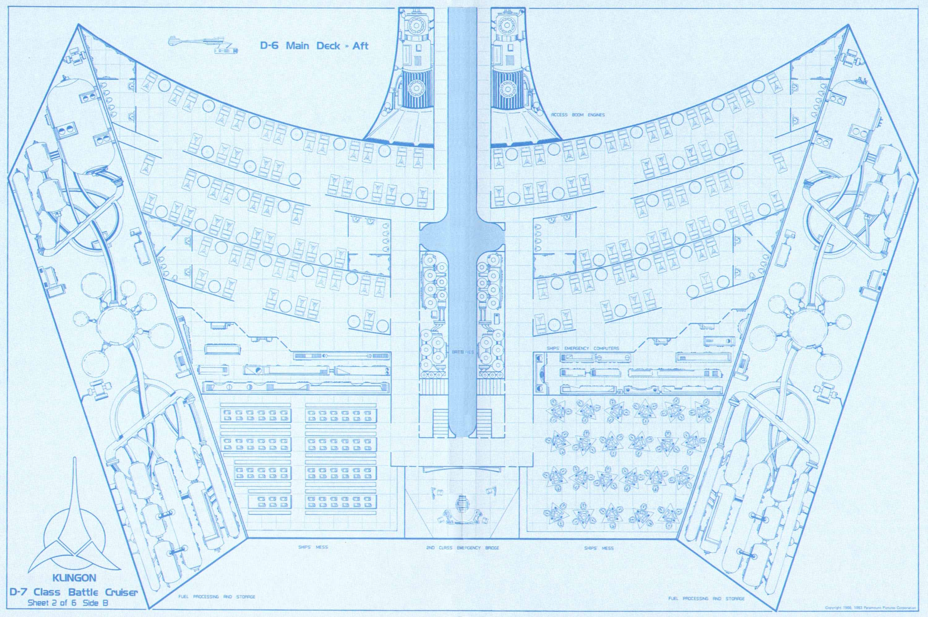
|
|
#
?
Jun 7, 2022 19:20
|
|

|
It is a problem that a lot of ship layout designs don't put much thought into how large the bulkhead needs to be to do whatever it does, or pay much attention to alloting space for internal maintenance to be done, where the engines are located, all the technical bits. I think one way to look at it is just like how RPG maps will prioritize the areas that people can normally inhabit while also prioritizing keeping the layout simple and one-level, real-world pictures depicting real-world ship layouts will often be more simplified, contouring closely to the outer shape of the ship without much attention paid to the places where all the technical bits are. I think I'd even say for most people more symbolic maps will work better for the purposes of navigation.  Can't believe they still built the common area around a dejarik table. Another thing about real ships (at least smaller ones) is that there's more space for people to just hang out on top of the ship. Can't really do that in space. It makes me think maybe most spaceships might need more open common rooms to deal with people who can't stand submarine living.  There are some ships that go through the effort at least of depicting area that isn't used by the living space interior, although it's up for grabs on whether that means there's any crawlspace for internal maintenance or whether everything needs to be done externally. There's not many ship maps that just depict internal mechanisms.  I developed some kind of fascination with the Jumpmaster 5000 because it's kind of the inverse of the Millennium Falcon. Instead of a flying saucer with bits on top to become more rocket-like, it's a rocket with bits on to make it into a flying saucer. And the main engines have a room to service them as part of the living quarters. It's a neat little thing.
|
|
#
?
Jun 7, 2022 21:52
|
|
|
SlothfulCobra posted:I think a lot of the issues with fantasy maps stem from how many of the most common maps of the current day don't really depict many of the critical factors of geography that affects people's lives, especially for the periods that they deal with. Political maps tend to be focused on borders in the way that modern nation-states concieve of them, and many maps people are familiar with come from a tradition of maps designed primarily for ocean navigation rather than terrain or forests or even most rivers. There are topographical styles of map that show mountains, but then it's hard for many people to wrap their heads around what it means for one area of a map to be brown and the other to be green. I don't think I've ever seen any fantasy maps that go for a more roadmap style or something more distorted or geometric like many medieval depictions of the world tend to be. Yea, I think that's it. I've studied a lot of history so I have a good idea how countries have change over the centuries, especially in Europe. Every kingdom, empire, dukedom, earldom and so on was defined by the geographic features. The mountain rangers are a big one, along with rivers, because these natural barriers prevented the locals from expanding any further. I don't want to be the guy who goes on about his totally going to be written fantasy novel some day, please don't steal, but when thinking about the map, which is honestly where i started, I thought about this kind of stuff. Most of the kingdoms are separated by some kind of landscape. There are a mountains or hilly areas that separate them, or rivers. But in some cases I made the boarder kind of ambiguous. Between two for example there is a large swampy area that neather really controls because you can't do much with peaty water and dead trees and various animals. There are causeways and roads through it, but they are barely maintained. Or another, a kingdom in its south just has no boarder. Yea they claim they own everything but there isn't anything there but endless grasslands until you get to what they call a free city. Anyways, yes floor plans for ships and builds and layouts of cities are certainly welcome! And yes, you can tell that many designers don't actually know how spaceships would actually be laid out. They think of them as ships, but they'd be more submarines. Look at a Los Angeles Class SSN  it has an outer pressure hull and then interior hulls where everyone lives and works and where the storage and weapons are actually located. Spaceships would be the same design. They'd have space between the outer and inner hulls. The Normandy SR2 in Mass Effect 2 is a great example, you can see the pressure hulls every time you move around the ship during the loading screens. But a lot of shows have the hulls right up against each other. That is a terrible idea. A hull breach means instant death for anyone inside there. grassy gnoll posted:
What is this from?
|
|
#
?
Jun 8, 2022 04:56
|
|
|
twistedmentat posted:What is this from? I had to google it but it looks like it's from Dishonored.
|
|
#
?
Jun 8, 2022 05:17
|
|

|
twistedmentat posted:Yea, I think that's it. I've studied a lot of history so I have a good idea how countries have change over the centuries, especially in Europe. Every kingdom, empire, dukedom, earldom and so on was defined by the geographic features. The mountain rangers are a big one, along with rivers, because these natural barriers prevented the locals from expanding any further. I am not sure how true this is. The Rhine would seem to be an obvious border; and it mostly is. But there are plenty of areas on one side of the Rhine that belong to the country / canton / whatever it was 500 years ago on the other side. There are also areas that were bought by some ritter and for some reason after that never got conquered by someone else and so stayed here, instead of there (e.g. the upper exclave here).  not sure if that image is displaying correctly, but it's linked from here (sorry only in German) https://de.wikipedia.org/wiki/Schwarzbubenland There's no geographical barrier between the upper part in Switzerland and that part of France. Below the upper part is the first chain of the Jura, but the flatish valley part there is then shared by Basel-Land and Solothurn. And the border is not along the river. Also why are there two exclaves? And the tiny bit between the exclaves is, speaking geographically, actually also an exclave since it's on the other side of the mountains (and the road passes through part of the upper exclave). And then in the middle part of the map going south there are 2 more chains which would make much more logical borders. History and the borders it left us do not have to be logical.
|
|
#
?
Jun 8, 2022 12:50
|
|

|
Yeah, there is kind of an ambiguity to how much the terrain itself forges the shape of nations and cultures, and France is a great example. You can see obviously where they have a border with Spaine, and you can sort of see how Aquitane/Gascony and Burgundy/Arles had a bunch of independent periods, but what you can't see is what makes the border between France and Belgium, or why Britanny had a longer history of independence than any other part of France. Why should Lyon be connected with Paris instead of Geneva, which it has a nice river pathway with?
|
|
#
?
Jun 8, 2022 16:07
|
|
|
Lmao, a hexagon map, that looks so fake
|
|
#
?
Jun 8, 2022 17:46
|
|
|
I don't mean its a hard and fast rule, but its not uncommon. Old Human Nations tended to be divided by geography but when we learned to work things out, boarders could be established that were literally just lines on a map.
|
|
#
?
Jun 8, 2022 17:55
|
|
|
All that is also likely why the majority of fantasy setting maps don't have many straight lines as boarders (in general). For example, if you look at a map of the US there are a lot of boarders between states where it looks like after some political agreement some guys just sat down at a drafting table and went "this state stops here, that one starts on the other side of the line we drew" or the boarder with Canada being "hey, let's make it about here most of the way across and call it good, cool? cool." It's much more engaging in a fantasy or similar setting to think of natural boarders defined by breathtaking mountains and mighty rivers, or ones that are set because two nations are at odds with each other, then an arbitrary agreed on straight line. Even if it is a diplomatically agreed boarder, "at the edge of the forest begins the kingdom of the elves" or whatever is more interesting then a set of coordinates.
|
|
#
?
Jun 9, 2022 03:52
|
|
|
I'd argue that making major rivers borders tends to be pretty artificial. Like, France's eastern border being pushed to the Rhine was a policy of the french state, with the traditional latin-german culture border being more like the Vosges mountains in western Alsace. Before that it was Rome that used the Danube and Rhine. Rivers "organically" tend to facilitate rather than hinder interaction. It takes a modern state to declare one a border. So it kinda makes sense for fantasy maps to use rivers since modern medieval fantasies usually have extremely modern states cosplaying medieval.
|
|
#
?
Jun 9, 2022 08:48
|
|
|

|
|
#
?
Jun 9, 2022 15:57
|
|


|
I'm the gorilla communes
|
|
#
?
Jun 9, 2022 16:43
|
|
|
Lawman 0 posted:I'm the gorilla communes my alpha tiger bros are gonna devour you
|
|
#
?
Jun 9, 2022 17:12
|
|

|
SlothfulCobra posted:Yeah, there is kind of an ambiguity to how much the terrain itself forges the shape of nations and cultures, and France is a great example. Somebody please post the map of Europe/asia with the comments on how the designer obviously ran out of ideas, everything looks fake etc
|
|
#
?
Jun 9, 2022 17:12
|
|

|
I prefer the full map even if it lacks some of the details.  You can tell it's from the 70s because they don't do anything for Japan.
|
|
#
?
Jun 9, 2022 18:50
|
|
|
Here's a more complete world map: The Orangutan surfing civilization seems like a relatively chill place to hang out and get away from the hustle and bustle of the Kangaroo Rat Murder Society
|
|
#
?
Jun 9, 2022 18:51
|
|
|
twistedmentat posted:like Rivers do not branch off in the direction they're flowing but a lot of fictional maps have that. No real world river does that, all their tributaries flow into the main river. Atchafalaya.
|
|
#
?
Jun 10, 2022 20:15
|
|

|
twistedmentat posted:Its interesting looking to see which ones were made by people who actually know how geography works, like Rivers do not branch off in the direction they're flowing but a lot of fictional maps have that. No real world river does that, all their tributaries flow into the main river. There's actually a word for when rivers do that.
|
|
#
?
Jun 10, 2022 20:31
|
|

|

|
| # ? Apr 26, 2024 10:21 |
|
|
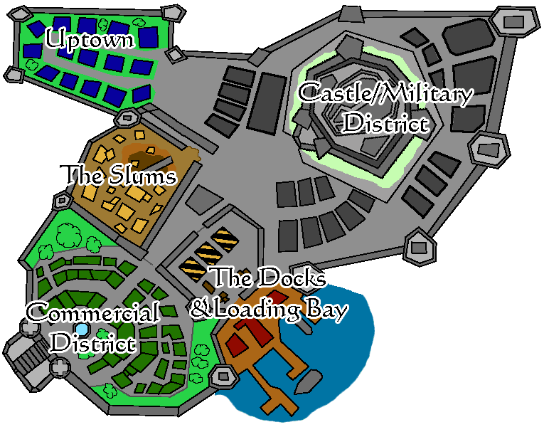
Can't believe it took that long for the Kamandi map to get posted. I'll contribute the original Neverwinter Nights game map, which I once found printed as the pattern on a paper bag I bought pick n mix in:  And the Baldur's Gate 2 game map, which just gives me warm fuzzy feelings: 
|
|
#
?
Jun 10, 2022 21:36
|
|